|
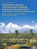
Relationship between arid geomorphic settings and unsaturated zone flow: case study, Chihuahuan desert, Texas |
Scanlon, B.R., Goldsmith, R.S., Langford, R.P. |
2000 |
Report of Investigations |
|
Regional stratigraphic cross sections, Comanche Cretaceous (Fredericksburg - Washita Division), Edwards and Stockton plateaus, West Texas: interpretation of sedimentary facies, depositional cycles, and tectonics |
Smith, C.I., Brown, J.B., Lozo, F.E. |
2000 |
Cross Sections |
|
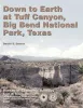
Down to earth at Tuff Canyon, Big Bend National Park, Texas |
Barker, D.S. |
2000 |
Down To Earth |
|
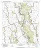
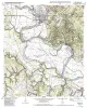
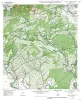
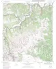
Geologic map of the Blanco Lake quadrangle, Texas |
Collins, E.W. |
2000 |
Open-File Map |
|
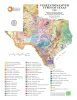
Vegetation/Cover Types of Texas |
Frye, R.G., Brown, K.L., McMahan, C.A. |
2000 |
Thematic Maps |
|
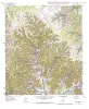
Geologic map of the Bastrop quadrangle, Texas |
Collins, E.W. |
2000 |
Open-File Map |

|
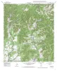
Geologic map of the Magers Crossing Quadrangle, Texas |
Collins, E.W. |
1999 |
Open-File Map |
|
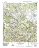
Geologic map of the Sabinal Canyon quadrangle, Texas |
Collins, E.W. |
1999 |
Open-File Map |
|
Geologic map of the Seco Pass Quadrangle, Texas |
Collins, E.W. |
1999 |
Open-File Map |
|
Twin vertical-seismic-profile (VSP) simulation of crosswell seismic tomography |
Simmons, J.L., Jr. |
1999 |
Report of Investigations |
|
3-D seismic interpretation of deep, complex structures in the Delaware Basin, West Texas |
Hardage, B.A., Pendleton, V.M., Asquith, G.B. |
1999 |
Geological Circular |
|
Geologic and engineering characterization of turbidite reservoirs, Ford Geraldine Unit, Bell Canyon Formation, West Texas |
Dutton, S.P., Barton, M.D., Asquith, G.B., Malik, M.A., Cole, A.G., Gogas, John, Guzman, J.I., Clift, S.J. |
1999 |
Report of Investigations |
|
Groundwater availability in the Carrizo-Wilcox aquifer in central Texas -- numerical simulations of 2000 through 2050 withdrawal projections |
Dutton, A.R. |
1999 |
Report of Investigations |
|
Geologic map of the Comanche Waterhole quadrangle, Texas |
Collins, E.W. |
1999 |
Open-File Map |
|
Using airborne geophysics to identify salinization in West Texas |
Paine, J.G., Dutton, A.R., Blum, M.U. |
1999 |
Report of Investigations |
|
Rocks, Resources, and Recollections, A Geologic Tour of the "Forty Acres" - The University of Texas at Austin Campus |
Woodruff, C.M., Jr., Kirkland, Brenda L. |
1999 |
Austin Geological Society |
|
GCAGS Transactions Volume 49 (1999) Lafayette |
|
1999 |
Gulf Coast Association of Geological Societies |
|
Geologic map of the Briggs quadrangle, Texas |
Collins, E.W. |
1999 |
Open-File Map |
|
Annual Report of the Bureau of Economic Geology 1999 |
University of Texas at Austin, Bureau of Economic Geology |
1999 |
Annual Reports |
|
Geologic map of the Nameless Quadrangle, Texas |
Collins, E.W. |
1999 |
Open-File Map |