|
Geologic map of the Coupland quadrangle, Texas |
Collins, E.W. |
2000 |
Open-File Map |
|
Legends in Wildcatting 2000 |
|
2000 |
Houston Geological Society |
|
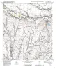
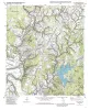
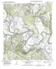
Geologic map of the Trio quadrangle, Texas |
Collins, E.W. |
2000 |
Open-File Map |
|
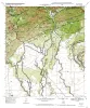
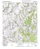
Geologic map of the Elgin East Quadrangle, Texas |
Collins, E.W. |
2000 |
Open-File Map |
|
Characterization of bedded salt for storage caverns -- a case study from the Midland Basin, Texas |
Hovorka, S.D. |
2000 |
Geological Circular |
|
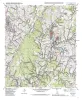
Geologic map of the Utopia quadrangle, Texas |
Collins, E.W. |
2000 |
Open-File Map |
|
Geologic map of the Elgin West Quadrangle, Texas |
Collins, E.W. |
2000 |
Open-File Map |
|
Geologic map of the Vanderpool quadrangle, Texas |
Collins, E.W. |
2000 |
Open-File Map |
|
Geologic map of the Lake Bastrop Quadrangle, Texas |
Collins, E.W. |
2000 |
Open-File Map |
|
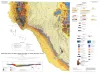
Geologic Map of the New Braunfels, Texas, 30x60 Minute Quadrangle |
Collins, E.W. |
2000 |
Miscellaneous Map |
|
Geologic map of the Structure Quadrangle, Texas |
Collins, E.W. |
2000 |
Open-File Map |
|
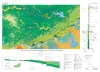
Geologic Map of West Hueco Bolson, El Paso Region, Texas |
Collins, E.W., Raney, J.A. |
2000 |
Miscellaneous Map |
|
Geologic map of the Utley Quadrangle, Texas |
Collins, E.W. |
2000 |
Open-File Map |
|
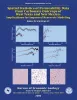
Spatial Statistics of Permeability Data from Carbonate Outcrops of West Texas and New Mexico: Implications for Improved Reservoir Modeling |
Jennings, J.W., Jr. |
2000 |
Report of Investigations |
|
Geology and Historical Mining, Llano Uplift Region, Central Texas |
Caran, S.C., Helper, M.A., Kyle, J.R. |
2000 |
Austin Geological Society |
|
GCAGS Transactions Volume 50 (2000) Houston |
|
2000 |
Gulf Coast Association of Geological Societies |
|
Applications of Sequence Stratigraphy |
|
2000 |
Gulf Coast Association of Geological Societies |
|
Pavement Deflection and Seismic Refraction for Determining Bedrock Type, Depth, and Physical Properties beneath Roads |
Paine, J.G., Murphy, M.R. |
2000 |
Report of Investigations |
|
Annual Report of the Bureau of Economic Geology 2000 |
University of Texas at Austin, Bureau of Economic Geology |
2000 |
Annual Reports |
|
Petrophysical characterization and distribution of remaining mobile oil: South Cowden Grayburg Reservoir, Ector County, Texas |
Lucia, F.J. |
2000 |
Report of Investigations |