Publication Details
Get the Publication
Abstract/Description:
These circulars issued from the Bureau of Economic Geology contain the record of cores and cuttings from well received and described in the Bureau. In some instances, driller's logs and other data are given, although it is usually impracticable to include logs of all wells, the logs given being selected as representative of the county or area to which the circular relates. The elevations given are for the most part those reported with the driller's log. In some instances the elevation given, as indicated, is that obtained from the location of the well on the topographic map. In all cases the elevation is to be regarded as approximate only.--- E. H. Sellards
This circular consists of the following two sections:
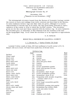
J. J. Brown No. 1, Reiter-Foster Oil Corp., located 3 miles south of Dale. Samples described by O. M. Richey and E. M. Hawtof, submitted by Mr. Clark, R. T. Short, and H. H. Cooper, 1926
C. L. Lackey No. 1, E. E. Smith Oil Co., located 822 feet north 45 west and 565 feet north 30 east of the most sourtherly corner of the C.L. Lackey 166-acre tract. Samples described by O. M. Richey, submitted by R. T. Short, 1927.