Publications in Caldwell
| Title | Publication Year Sort ascending | Abstract | Author | Series | Publisher | |
|---|---|---|---|---|---|---|
|
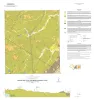
Geologic Map of the Creedmoor Quadrangle, Texas | 2022 | Woodruff, C.M., Jr., Costard, L. | Open-File Map | Bureau of Economic Geology | |
|
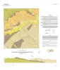
Geologic map of the Lytton Springs quadrangle, Texas | 2021 | Woodruff, C.M., Jr., Costard, L. | Open-File Map | Bureau of Economic Geology | |
|
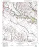
Geologic map of the Uhland quadrangle, Texas | 2002 | Collins, E.W. | Open-File Map | Bureau of Economic Geology | |
|
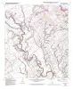
Geologic map of the Martindale quadrangle, Texas | 2002 | Collins, E.W. | Open-File Map | Bureau of Economic Geology | |
|
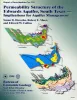
Permeability structure of the Edwards aquifer, south Texas -- implications for aquifer management | 1998 | This report describes the three-dimensional distribution of hydraulic conductivity in the Edwards aquifer from Kinney to Comal Counties, Texas. |
Hovorka, S.D., Mace, R.E., Collins, E.W. | Report of Investigations | Bureau of Economic Geology |
|
The Guadalupe - Lavaca - San Antonio - Nueces River basins regional study: Seguin West - Austin West sheets | 1985 | Wermund, E.G., Gustavson, T.C., Morton, R.A., Woodruff, C.M., Jr., Macpherson, G.L., McKinney, L., Nilsson, J., Waddell, C.T. | River Basins Regional Studies | Bureau of Economic Geology | |
|
Depositional and diagenetic history of the Sligo and Hosston Formations(Lower Cretaceous) in south Texas | 1981 | The Sligo and Hosston Formations of Aptian age occur over thousands of square miles in the subsurface of South Texas. |
Bebout, D.G., Budd, D.A., Schatzinger, R.A. | Report of Investigations | Bureau of Economic Geology |

|
Structural cross sections, Tertiary formations, Texas Gulf Coast | 1981 | The publication comprises 24 structural dip cross sections, spaced 15 to 20 mi apart along the Texas coast, and 4 structural strike cross sections. Dip sections extend from near the Wilcox outcrop to the coastline. |
Dodge, M.M., Posey, J.S. | Cross Sections | Bureau of Economic Geology |

|
Environmental geology of the Wilcox Group lignite belt, east Texas | 1979 | This report provides a data base for decisions about lignite mining and reclamation in the Wilcox Group of East Texas. Kaiser (1974, 1978) estimates that about 12.2 billion short tons of potentially strip-minable lignite resources occur in East and South Texas. |
Henry, C.E., Basciano, J.M. | Report of Investigations | Bureau of Economic Geology |
|
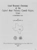
Land resource overview of the Capital Area Planning Council Region, Texas -- a nontechnical guide | 1979 | Bastrop, Blanco, Burnet, Caldwell, Fayette, Hays, Lee, Llano, Travis, and Williamson Counties make up the Capital Area Planning Council (CAPCO) region in Central Texas (fig. 1). The region covers 8,427 square miles (21,826 km2) and includes land of great physical diversity. |
Woodruff, C.M., Jr. | Selected Reports | Bureau of Economic Geology |