Publication Details
Get the Publication
Abstract/Description:
These circulars issued from the Bureau of Economic Geology contain the record of cores and cuttings from well received and described in the Bureau. In some instances, driller's logs and other data are given, although it is usually impracticable to include logs of all wells, the logs given being selected as representative of the county or area to which the circular relates. The elevations given are for the most part those reported with the driller's log. In some instances the elevation given, as indicated, is that obtained from the location of the well on the topographic map. In all cases the elevation is to be regarded as approximate only.--- E. H. Sellards
This circular consists of the following sections:
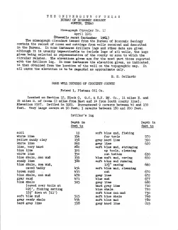
Friend 1, Plateau Oil Co., located 11 miles east and 14 miles south of Ozona, drilled in 1921, Encountered 9 caverns between 40 and 150 feet; very large cavern at 90 feet; 3 caverns between 180 and 200 feet.
Samples described by E. T. Kniker and E. B. Stiles, submitted by Houston Smith, 1921.
Henderson 1, Ryan Petroleum Co., located 4 miles from East and 16 miles from North county line, drilled 1919-1920. Samples described by Hedwig T. Kniker, submitted by Houston Smith, 1920.
Shannon 1, Crockett Drilling Syndicate, located 11 miles from north county line and approximately south of Powell field.