Get the Publication
Abstract/Description:
These circulars issued from the Bureau of Economic Geology contain the record of cores and cuttings from well received and described in the Bureau. In some instances, driller's logs and other data are given, although it is usually impracticable to include logs of all wells, the logs given being selected as representative of the county or area to which the circular relates. The elevations given are for the most part those reported with the driller's log. In some instances the elevation given, as indicated, is that obtained from the location of the well on the topographic map. In all cases the elevation is to be regarded as approximate only.--- E. H. Sellards
This circular consists of the following sections:
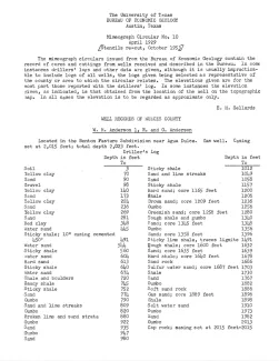
W. R. Anderson 1, R. and G. Anderson, gas well, driller's log, located in the Benton Pasture Subdivision near Agua Dulce.
Evelyn 1, located on the beach near Corpus Christi
John Dunn 1, Pioneer Oil Company, located about 5 miles west of Corpus Christi
Reed & Perry 2, located north of the railroad, 5 miles west of Corpus Christi, samples described by E. H. Sellards and O. M. Richey, submitted by Edgar Perry, 1927
Roberts 1, Mitchell, Gilliland, and Radcliff, located 12 miles west of Corpus Christi, samples described by J. A. Udden and P. F. Seashore, submitted by H. O. Radcliff.