|
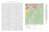
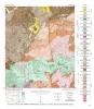
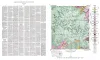
Geologic map of the Squaw Creek Quadrangle, Gillespie and Mason Counties, Texas |
Barnes, V.E. |
1952 |
Geologic Quadrangle Map |
|
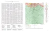
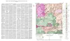
Geologic map of the Hilltop Quadrangle, Gillespie, Llano, and Mason Counties, Texas |
Barnes, V.E. |
1952 |
Geologic Quadrangle Map |
|
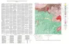
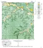
Geologic Map of the Crabapple Creek Quadrangle Gillespie and Llano Counties, Texas |
Barnes, V.E. |
1952 |
Geologic Quadrangle Map |
|
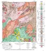
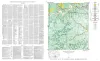
Geologic map of the Willow City quadrangle, Gillespie and Llano Counties, Texas |
Barnes, V.E. |
1952 |
Geologic Quadrangle Map |
|
Geologic Map of the Blowout Quadrangle, Blanco, Gillespie, and Llano Counties, Texas |
Barnes, V.E. |
1952 |
Geologic Quadrangle Map |
|
Geologic map of the Spring Creek Quadrangle, Gillespie County, Texas |
Barnes, V.E. |
1952 |
Geologic Quadrangle Map |
|
Geologic map of the Live Oak Creek Quadrangle, Gillespie County, Texas |
Barnes, V.E. |
1952 |
Geologic Quadrangle Map |
|
Geologic map of the Palo Alto Creek Quadrangle, Gillespie County, Texas |
Barnes, V.E. |
1952 |
Geologic Quadrangle Map |
|
Geologic map of the Gold Quadrangle, Gillespie County, Texas |
Barnes, V.E. |
1952 |
Geologic Quadrangle Map |
|
Geologic map of the North Grape Creek Quadrangle, Blanco and Gillespie County, Texas |
Barnes, V.E. |
1952 |
Geologic Quadrangle Map |
|
Geologic map of the Morris Ranch quadrangle, Gillespie and Kerr Counties, Texas |
Barnes, V.E. |
1952 |
Geologic Quadrangle Map |

|
Geologic map of the Bear Creek quadrangle, Gillespie, Kerr, and Kendall Counties, Texas |
Barnes, V.E. |
1952 |
Geologic Quadrangle Map |
|
Geologic map of the Cain City quadrangle, Gillespie and Kendall Counties, Texas |
Barnes, V.E. |
1952 |
Geologic Quadrangle Map |
|
Geologic map of the Stonewall quadrangle, Gillespie and Kendall Counties, Texas |
Barnes, V.E. |
1952 |
Geologic Quadrangle Map |