Publication Details
Geolocation:
Get the Publication
$14.50
Abstract/Description:
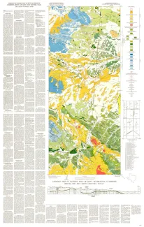
Study of Permian, Cretaceous, and Cenozoic rocks in the 30 Kent quad- rangle is important to an understanding of the geology of Trans-Pecos Texas. Most of the Cretaceoua rock units of central Texas lose their lithostratigraphic identity when traced into west Texas. The Kent quadrangle, astride the Diablo Platform, is one of the critical areas of intervening stratigraphy between central Texas to the east and the geosyncline in Mexico to the west and southwest. Permian units have been studied exten- sively in areas of outcrop in west Texas and stratigraphic relationships of the Permian beds are fairly well known. Likewise, subsurface Paleozoic units within the Delaware basin are well known. To the southwest, beyond the margin of the Diablo Platform, surface and subsurface Permian rocks are in- completely known. It is hoped that a study of the younger rocks in the latter area might reveal characteristics which will possibly reflect late Paleozoic tectonic elements. The accompanying map, covering the area bounded by 104�00� and 104�15� west and 31�00� and 31�30� north, is the firat of a series of areal geologic maps of the region. Ad- joining areas are currently under investi- gation by severa]l workers. The Kent region is arid; numerous intermittent streams, the largest of which are Cottonwood Draw, China Draw, Salt Draw, San Martine Draw, and Hurd Draw, drain the area. Cottonwood Draw (King, 1949) rises west of the Kent quadrangle and flows eastward across the Gypsum Plain (Richardson, 1904, p. 22); its course lies mostly outside the map area. Salt Draw and China Draw also rise in a gypsum terrain and trend castwardly through the central part of the quadrangle. Hurd Draw and San Martine Draw rise in the Davis Moun- tains. Cottonwood Draw discharges into the Toyah basin but does not reach the Pecos River. The others ultimately dis- charge into Toyah Lake southeast of Pecos, about 45 miles northeast of Kent, and the overflow from the lake enters the Pecos River. Thus the Toyah basin is a �semi-bolson� (Tolman, 1909, p. 141). Most of the annual rainfall of 13 inches occurs as thunder-showers during the sammer months; immediately following heavy rains, stream channels flood to truncated collapsed units. Probably the age of the major collapse is pre-Gatuna; perhaps the dissolving of the gypsum began� late in the Tertiary Period after the regional uplift that accompanied the block faulting farther west. The profusion of faults of low displace- ment in the vicinity of Davis Mountain Station can probably be attributed to solution of the Castile Gypsum. Undoubt- edly, many similar faults are concealed beneath the alluvium in the flat in the central portion of the area.