Publications in Real
| Title | Publication Year Sort ascending | Abstract | Author | Series | Publisher | |
|---|---|---|---|---|---|---|
|
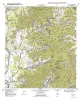
Geologic map of the Circle Bluff quadrangle, Texas | 2001 | Collins, E.W. | Open-File Map | Bureau of Economic Geology | |
|
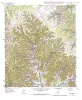
Geologic map of the Rio Frio quadrangle, Texas | 2001 | Collins, E.W. | Open-File Map | Bureau of Economic Geology | |
|
Regional stratigraphic cross sections, Comanche Cretaceous (Fredericksburg - Washita Division), Edwards and Stockton plateaus, West Texas: interpretation of sedimentary facies, depositional cycles, and tectonics | 2000 | Six interlocking regional stratigraphic cross sections of Lower Cretaceous strata (middle Albian-lower Cenomanian) of the Edwards and Stockton Plateaus of West Texas illustrate the vertical and lateral extent of lithostratigraphic units and distribution of facies and facies tracts. |
Smith, C.I., Brown, J.B., Lozo, F.E. | Cross Sections | Bureau of Economic Geology |
|
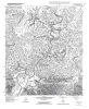
Geologic map of the Sabinal Canyon quadrangle, Texas | 1999 | Collins, E.W. | Open-File Map | Bureau of Economic Geology | |
|
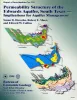
Permeability structure of the Edwards aquifer, south Texas -- implications for aquifer management | 1998 | This report describes the three-dimensional distribution of hydraulic conductivity in the Edwards aquifer from Kinney to Comal Counties, Texas. |
Hovorka, S.D., Mace, R.E., Collins, E.W. | Report of Investigations | Bureau of Economic Geology |
|
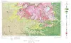
Geologic Atlas of Texas, Llano sheet | 1981 | Geologic map that depicts the surface geology of Mason, Llano, and Gillespie Counties and parts of Menard, Kimble, San Saba, McCulloch, Edwards, Real, Kerr, Kendall, Blanco, Hays, Travis, Williamson, and Burnet Counties, Texas. |
Barnes, V.E., Shell Oil Co., Boyer, R.E., Clabaugh, S.E., Baker, E.T. | Geologic Atlas of Texas | Bureau of Economic Geology |
|
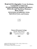
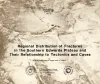
Regional distribution of fractures in the southern Edwards Plateau and their relationship to tectonics and caves | 1977 | In order to better understand the control exerted by fractures on the recharge and production zones of limestone aquifers, the authors delineated surficial fracture zones in the southern Edwards Plateau, Texas. Lineations were marked on nearly 200 mosaics scale of 1:24,000. |
Wermund, E.G., Cepeda, J.C., Luttrell, P.E. | Geological Circular | Bureau of Economic Geology |
|
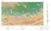
Geologic Atlas of Texas, San Antonio sheet (revised 1982) | 1974 | Geologic map that depicts the surface geology of Comal, Bandera, Bexar, and Medina Counties and parts of Real, Kerr, Kendall, Hays, Guadalupe, Wilson, Atascosa, Frio, Zavala, and Uvalde Counties, Texas. The 9-page booklet indicates geologic formations, abbreviations, and ages. |
Barnes, V.E., Shell Oil Co., Amerada Petroleum Corp., Brown, T.E., Waechter, N.B., Dillon, R.L. | Geologic Atlas of Texas | Bureau of Economic Geology |