Publications in Parker
| Title | Publication Year Sort ascending | Abstract | Author | Series | Publisher | |
|---|---|---|---|---|---|---|
|
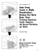
Atoka Group (Lower to Middle Pennsylvanian), northern Fort Worth basin, Texas: terrigenous depositional systems, diagenesis, and reservoir distribution and quality | 1982 | The Fort Worth Basin, in North-Central Texas, is a late Paleozoic foreland basin that was downwarped during the Early to Middle Pennsylvanian Period in response to tectonic stresses that also produced the Ouachita Thrust Belt. |
Thompson, D.M. | Report of Investigations | Bureau of Economic Geology |
|
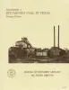
Bituminous coal in Texas | 1974 | Coal is found in six areas in Texas, including the large North-Central Texas field, a distinctive cannel coalfield in Webb County, and Late Cretaceous-age coals near Eagle Pass. |
Evans, T.J. | Handbook | Bureau of Economic Geology |
|
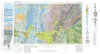
Geologic Atlas of Texas, Abilene sheet | 1972 | Geologic map that depicts the surface geology of Shackelford, Stephens, Palo Pinto, Callahan, and Eastland Counties and parts of Jones, Taylor, Runnels, Coleman, Brown, Comanche, Erath, Parker, and Hood Counties, Texas. |
Barnes, V.E., Brown, L.F., Jr., Goodson, J.L., Southern Minerals Corp., Humble Oil and Refining Co., Shell Oil Co., Harwood, P., Bloomer, R.R. | Geologic Atlas of Texas | Bureau of Economic Geology |
|
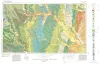
Geologic Atlas of Texas, Dallas sheet (revised 1987) | 1972 | Geologic map that depicts surface geology of Tarrant, Dallas, Kaufman, Ellis, Johnson, Somervell, and Rockwall Counties and parts of Parker, Hood, Erath, Bosque, Hill, Navarro, Henderson, Van Zandt, and Hunt Counties, Texas. |
Barnes, V.E., Shell Oil Co., Humble Oil and Refining Co., Dallas Geological Society, Fort Worth Geological Society, McGowen, J.H., Proctor, C.V., Jr., Haenggi, W.T. | Geologic Atlas of Texas | Bureau of Economic Geology |
|
Lower Cretaceous sands of Texas: stratigraphy and resources | 1967 | Lower Cretaceous sands have long been important aquifers in Central, North-Central, and North Texas. In recent years these sands also have been sources of high-silica industrial or specialty-purpose sand. |
Fisher, W.L., Rodda, P.U. | Report of Investigations | Bureau of Economic Geology |
|
Nomenclature revision of basal Cretaceous rocks between the Colorado and Red Rivers, Texas | 1966 | Based on need for convenient, small-scale cartographic units, the basal Cretaceous rocks in Texas from Red River to Burnet County and on the Callahan Divide are herein divided into three distinctive lithologic sequences. |
Fisher, W.L., Rodda, P.U. | Report of Investigations | Bureau of Economic Geology |
|
Geology of Parker County, Texas | 1957 | Hendricks, Leo | UT Publication | ||
|
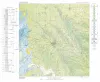
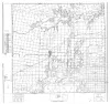
Geologic map of Parker County, Texas | 1937 | Armstrong, J.M., Scott, Gayle | Miscellaneous Map | Bureau of Economic Geology | |
|
Geology of Palo Pinto County, Texas | 1936 | Plummer, F.B., Hornberger, Joseph, Jr. | UT Bulletin | ||
|
Selected Texas County Maps, 1929-1937 | 1929 | These are 21 Texas county maps made in cooperation with the American Association of Petroleum Geologists and Society of Economic Paleontologists and Mineralogists, issued between 1929 and 1932 and revised in 1937. |
Miscellaneous Map | Bureau of Economic Geology |