Publications in Palo Pinto
| Title | Publication Year Sort ascending | Abstract | Author | Series | Publisher | |
|---|---|---|---|---|---|---|
|
Geologic Atlas of Texas, Wichita Falls-Lawton sheet | 1987 | Geologic map that depicts the surface geology of Hardeman, Wilbarger, Wichita, Clay, Knox, Baylor, Archer, Haskell, Throckmorton, Young, and Foard Counties and part of Jack County, Texas. The 20-page booklet indicates geologic formations, abbreviations, and ages. |
Barnes, V.E., Hentz, T.F., Brown, L.F., Jr., Cleaves, A.W., Kier, R.S., McGowen, J.H., Parrish, W.C., Ramsey, J.W. | Geologic Atlas of Texas | Bureau of Economic Geology |

|
Atoka Group (Lower to Middle Pennsylvanian), northern Fort Worth basin, Texas: terrigenous depositional systems, diagenesis, and reservoir distribution and quality | 1982 | The Fort Worth Basin, in North-Central Texas, is a late Paleozoic foreland basin that was downwarped during the Early to Middle Pennsylvanian Period in response to tectonic stresses that also produced the Ouachita Thrust Belt. |
Thompson, D.M. | Report of Investigations | Bureau of Economic Geology |

|
The Mississippian and Pennsylvanian (Carboniferous) Systems in the United States -- Texas | 1980 | Kier, R.S., Brown, L.F., Jr., McBride, E.F. | Geological Circular | Bureau of Economic Geology | |

|
Upper Pennsylvanian limestone banks, north central Texas | 1975 | Nelson and others (1962) define a bank as " ... a skeletal deposit formed by organisms which do not have the ecologic potential to erect a rigid wave-resistant structure." They explain that a bank may have any geometry. |
Wermund, E.G. | Geological Circular | Bureau of Economic Geology |
|
Depositional systems in Canyon Group (Pennsylvanian System), north-central Texas | 1975 | The Canyon Group (Missourian Series) is a sequence of westward-dipping, genetically related carbonate and terrigenous clastic facies that crop out in a northeast-southwest belt across North-Central Texas. |
Erxleben, A.W. | Report of Investigations | Bureau of Economic Geology |

|
Bituminous coal in Texas | 1974 | Coal is found in six areas in Texas, including the large North-Central Texas field, a distinctive cannel coalfield in Webb County, and Late Cretaceous-age coals near Eagle Pass. |
Evans, T.J. | Handbook | Bureau of Economic Geology |

|
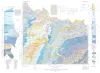
Geologic Atlas of Texas, Abilene sheet | 1972 | Geologic map that depicts the surface geology of Shackelford, Stephens, Palo Pinto, Callahan, and Eastland Counties and parts of Jones, Taylor, Runnels, Coleman, Brown, Comanche, Erath, Parker, and Hood Counties, Texas. |
Barnes, V.E., Brown, L.F., Jr., Goodson, J.L., Southern Minerals Corp., Humble Oil and Refining Co., Shell Oil Co., Harwood, P., Bloomer, R.R. | Geologic Atlas of Texas | Bureau of Economic Geology |

|
Lower Cretaceous sands of Texas: stratigraphy and resources | 1967 | Lower Cretaceous sands have long been important aquifers in Central, North-Central, and North Texas. In recent years these sands also have been sources of high-silica industrial or specialty-purpose sand. |
Fisher, W.L., Rodda, P.U. | Report of Investigations | Bureau of Economic Geology |

|
Nomenclature revision of basal Cretaceous rocks between the Colorado and Red Rivers, Texas | 1966 | Based on need for convenient, small-scale cartographic units, the basal Cretaceous rocks in Texas from Red River to Burnet County and on the Callahan Divide are herein divided into three distinctive lithologic sequences. |
Fisher, W.L., Rodda, P.U. | Report of Investigations | Bureau of Economic Geology |
|
Geology of Palo Pinto County, Texas | 1936 | Plummer, F.B., Hornberger, Joseph, Jr. | UT Bulletin |