Publications in Motley
| Title | Publication Year Sort ascending | Abstract | Author | Series | Publisher | |
|---|---|---|---|---|---|---|
|
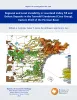
Regional and Local Variability in Lowstand Valley Fill and Deltaic Deposits in the Tannehill Sandstone (Cisco Group), Eastern Shelf of the Permian Basin | 2024 | Lowstand valley fill and shelf-edge deltaic deposits in the Tannehill sandstone (Wolfcampian Cisco Group) in the Eastern Shelf of the Permian Basin are major targets for oil and gas exploration. |
Ambrose, W.A., Hentz, T.F., Rogers, H., Carr, D.L. | Report of Investigations | Bureau of Economic Geology |

|
Regional depositional systems tracts, paleogeography, and sequence stratigraphy, Upper Pennsylvanian and Lower Permian strata, north- and west-central Texas | 1990 | Sixteen depositional sequences, commonly called cyclothems, each composed mostly of limestone(retrogradational/transgressive) and siliciclastic (progradational/regressive) subsequences, or systems tracts, record the paleogeography during Late Pennsylvanian (Virgilian Epoch) and Early Permian (Wol |
Brown, L.F., Jr., Solis-Iriarte, R.F., Johns, D.A. | Report of Investigations | Bureau of Economic Geology |
|
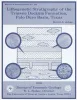
Lithogenetic stratigraphy of the Triassic Dockum Formation, Palo Duro basin, Texas | 1989 | Four clastic depositional sequences compose the lower part of the Triassic Dockum Formation in the Palo Duro Basin. |
Johns, D.A. | Report of Investigations | Bureau of Economic Geology |
|
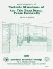
Tectonic structures of the Palo Duro basin, Texas panhandle | 1989 | The Palo Duro Basin is a broad structural low in the southern Texas Panhandle that formed as a result of nearly continuous Pennsylvanian and Permian subsidence. True complexity of this basin is unknown because of the sparsity of structural information. |
Budnik, R.T. | Report of Investigations | Bureau of Economic Geology |
|
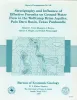
Stratigraphy and influence of effective porosity on ground-water flow in the Wolfcamp brine aquifer, Palo Duro basin, Texas panhandle | 1988 | In the Palo Duro Basin, the Wolfcampian Series (lower Permian) overlies Pennsylvanian (primarily Virgilian) strata and underlies the Wichita Group (Leonardian). |
Conti, R.D., Herron, M.J., Senger, R.K., Wirojanagud, Prakob | Report of Investigations | Bureau of Economic Geology |

|
Hydrogeology and hydrochemistry of the Ogallala aquifer, southern High Plains, Texas panhandle and eastern New Mexico | 1988 | The Ogallala aquifer, which underlies the Southern High Plains, consists of the saturated sediments of the Neogene Ogallala Formation. The aquifer is the main source of water for the High Plains of Texas and New Mexico and is being severely depleted by extensive pumpage for irrigation. |
Nativ, Ronit | Report of Investigations | Bureau of Economic Geology |
|
Geomorphic processes and rates of retreat affecting the Caprock Escarpment, Texas panhandle | 1988 | The interaction of geomorphic and ground-water processes has produced the Caprock Escarpmentthat bounds the eastern margin of the Southern High Plains in the Texas Panhandle. |
Gustavson, T.C., Simpkins, W.W. | Report of Investigations | Bureau of Economic Geology |
|
Hydrogeologic and hydrochemical properties of salt-dissolution zones, Palo Duro basin, Texas panhandle - preliminary assessment | 1987 | Ground water that moves downward from aquifers in clastic rocks of the Triassic Dockum Group and Neogene Ogallala Formation dissolves bedded halite and anhydrite in the Upper Permian evaporite section along the perimeter of the Southern High Plains in the Texas Panhandle. |
Dutton, A.R. | Geological Circular | Bureau of Economic Geology |
|
Regional stratigraphic cross sections, Upper Pennsylvanian and Lower Permian strata (Virgilian and Wolfcampian Series), north-central Texas | 1987 | This cross section set comprises 14 dip (E-W) sections and 9 strike (N-S) stratigraphic cross sections (with text), correlating upper Pennsylvanian (Virgilian) and lower Permian (Wolfcampian) strata throughout the subsurface in all or parts of 28 counties of North-Central Texas. |
Brown, L.F., Jr., Solis-Iriarte, R.F., Johns, D.A. | Cross Sections | |
|
Numerical modeling of regional ground-water flow in the deep-basin brine aquifer of the Palo Duro Basin, Texas panhandle | 1986 | A conceptual hydrogeologic model of the Palo Duro Basin, Texas Panhandle, subdivides the basin into three hydrogeologic units: (1) the shallow Ogallala and Dockum aquifers (Upper aquifer), (2) the Permian evaporite aquitard (Evaporite aquitard), and (3) the deep, confined, underpressured, princip |
Wirojanagud, Prakob, Kreitler, C.W., Smith, D.A. | Report of Investigations | Bureau of Economic Geology |