Publications in Mason
| Title | Publication Year Sort ascending | Abstract | Author | Series | Publisher | |
|---|---|---|---|---|---|---|
|
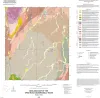
Geologic map of the Spice Rock quadrangle, Texas | 2015 | Elliott, Brent A. | Open-File Map | Bureau of Economic Geology | |
|
Petrography and diagenesis of a half-billion-year-old cratonic sandstone (Hickory), Llano region, Texas | 2002 | We studied the Hickory Sandstone Member of the Riley Formation, Central Texas, to assess the diagenetic history of a cratonic sandstone, which, in spite of its great age, remains porous and permeable where it has not been buried more than 1 km. |
McBride, E.F., Abdel-Wahab, A.A., Milliken, K.L. | Report of Investigations | Bureau of Economic Geology |
|
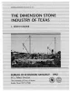
The dimension stone industry of Texas | 1992 | Garner, L.E. | Mineral Resource Circular | Bureau of Economic Geology | |
|
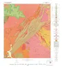
Geology of the Purdy Hill quadrangle, Mason County, Texas | 1982 | Mutis-Duplat, Emilio | Geologic Quadrangle Map | Bureau of Economic Geology | |
|
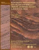
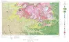
Geologic Atlas of Texas, Llano sheet | 1981 | Geologic map that depicts the surface geology of Mason, Llano, and Gillespie Counties and parts of Menard, Kimble, San Saba, McCulloch, Edwards, Real, Kerr, Kendall, Blanco, Hays, Travis, Williamson, and Burnet Counties, Texas. |
Barnes, V.E., Shell Oil Co., Boyer, R.E., Clabaugh, S.E., Baker, E.T. | Geologic Atlas of Texas | Bureau of Economic Geology |
|
The Moore Hollow Group of central Texas | 1977 | Middle and Upper Cambrian rocks and locally up to 90 feet of Lower Ordovician rocks in Central Texas, are here named the Moore Hollow Group. |
Barnes, V.E., Bell, W.C. | Report of Investigations | |
|
Trilobites of the Upper Cambrian Ptychaspid biomere, Wilberns Formation, central Texas | 1970 | Trilobites collected during the past 20 years from the Morgan Creek, Point Peak, and San Saba Members of the Wilberns Formation comprise 89 species assigned to 45 genera belonging to zones of the upper Franconian and Trempealeauan Stages of the Upper Cambrian Croixan Series. |
Longacre, S.A. | Report of Investigations | Bureau of Economic Geology |
|
Pre-Chappel conodonts of the Llano region, Texas | 1970 | This work was begun in 1964 and substantially completed in 1965; at that time conodont zones had been established in North America only for the Upper Devonian, by Clark and Becker (1960) for the Great Basin and Collinson, Scott, and Rexroad (1962) for the mid-continent. |
Seddon, George | Report of Investigations | Bureau of Economic Geology |
|
Late Cambrian and Early Ordovician faunas from the Wilberns Formation of central Texas | 1967 | The San Saba Member of the Wilberns Formation of central Texas is mostly coarse-grained, trilobitic limestone that grades eastward to dolomite and contains sandstone intervals in its westernmost exposures. |
Winston, Don, Nicholls, Harry | Report of Investigations | Bureau of Economic Geology |
|
Potential low-grade iron ore and hydraulic-fracturing sand in Cambrian sandstones, northwestern Llano region, Texas | 1964 | The red upper unit of the Hickory Sandstone is a hematitic and goethitic sandstone containing a large reserve of potential low-grade iron ore. |
Barnes, V.E., Schofield, D.A. | Report of Investigations | Bureau of Economic Geology |