Publications in Kleberg
| Title | Publication Year Sort ascending | Abstract | Author | Series | Publisher | |
|---|---|---|---|---|---|---|
|
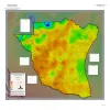
Geothermal Resources, South Texas | 2024 | A series of two 1:500,000 scale maps showing the Geothermal resources of South Texas. |
Andrews, J.R. | Open-File Map | Bureau of Economic Geology |
|
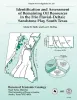
Identification and assessment of remaining oil resources in the Frio fluvial-deltaic sandstone play, south Texas | 1995 | The Frio Fluvial-Deltaic Sandstone (Vicksburg Fault Zone) play of South Texas has produced nearly 1 billion barrels (Bbbl) of oil since field development began in the 1940's. |
Holtz, M.H., McRae, L.E. | Report of Investigations | Bureau of Economic Geology |
|
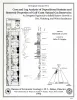
A 3-D seismic case history evaluating fluvially deposited thin-bed reservoirs in a gas-producing property | 1995 | Hardage, B.A., Levey, R.A., Pendleton, V.M., Simmons, J.L., Jr., Edson, R.D. | Geological Circular | Bureau of Economic Geology | |
|
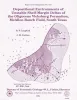
Depositional Environments of Unstable Shelf-Margin Deltas of the Oligocene Vicksburg Formation, McAllen Ranch Field, South Texas | 1994 | Cores and supporting petrophysical data from 20 wells in McAllen Ranch field were analyzed. |
Langford, R.P., Combes, J.M. | Report of Investigations | Bureau of Economic Geology |
|
Quantifying secondary gas resources in fluvial/deltaic reservoirs: a case history from Stratton field, south Texas | 1994 | Geologic and engineering studies were conducted within fluvial/deltaic strata of a mature South Texas field to determine the impact of reservoir compartmentalization on secondary gas recovery. Stratton is one of several mature South Texas fields containing fluvial and deltaic gas reservoirs. |
Levey, R.A., Finley, R.J., Sippel, M.A. | Report of Investigations | Bureau of Economic Geology |
|
Gas reservoir quality variations and implications for resource development, Frio Formation, south Texas: examples from Seeligson and Stratton fields | 1993 | Discovery of volcanic glass detritus in fluvial deposits of the middle Frio Formation (Seeligson and Stratton fields) of South Texas has resulted in a new classification of reservoir types (type I and type II) within this formation. |
Grigsby, J.D., Kerr, D.R. | Geological Circular | Bureau of Economic Geology |
|
Core and Log Analyses of Depositional Systems and Reservoir Properties ... in Frio, Vicksburg, and Wilcox Sandstones | 1992 | The Gas Research Institute, U.S. Department of Energy, and the State of Texas cooperated in joint-venture research to evaluate the infield reserve growth potential of mature gas fields containing conventional reservoirs. |
Levey, R.A., Grigsby, J.D. | Geological Circular | Bureau of Economic Geology |
|
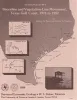
Shoreline and vegetation-line movement, Texas Gulf coast, 1974 to 1982 | 1989 | The purposes of this study were (1) to quantify recent (1974 to 1982) movement of Texas shorelines and vegetation lines by analysis of aerial photographs; (2) to place this movement in historical (pre-1974) context; and (3) to examine the influence of environmental variables such as storms, sea l |
Paine, J.G., Morton, R.A. | Geological Circular | Bureau of Economic Geology |
|
Submerged lands of Texas, Kingsville area: sediments, geochemistry, benthic macroinvertebrates, and associated wetlands | 1989 | The State-owned submerged lands of Texas encompass almost 6,000 mi2 (15,540 km2). They lie below waters of the bay-estuary-lagoon system and the Gulf of Mexico and extend 10.3 mi (16.6 km) seaward from the Gulf shoreline (fig. 1). |
White, W.A., Calnan, T.R., Morton, R.A., Kimble, R.S., Littleton, T.G., McGowen, J.H., Nance, H.S. | Submerged Lands of Texas | Bureau of Economic Geology |
|
Hydrocarbon production and exploration potential of the distal Frio Formation, Texas Gulf coast and offshore | 1989 | Along the Texas Gulf shoreline and offshore, the distal margin of the Frio Formation is a deep hydrocarbon province that is underexplored relative to the onshore Frio. |
Hamlin, H.S. | Geological Circular | Bureau of Economic Geology |