Publications in Kerr
| Title | Publication Year Sort ascending | Abstract | Author | Series | Publisher | |
|---|---|---|---|---|---|---|
|
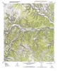
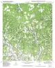
Geologic map of the Legion quadrangle, Texas | 2004 | Collins, E.W. | Open-File Map | Bureau of Economic Geology | |
|
Geologic map of the Bandera Pass quadrangle, Texas | 2004 | Collins, E.W. | Open-File Map | Bureau of Economic Geology | |
|
Geologic map of the Echo Hill Ranch quadrangle, Texas | 2004 | Collins, E.W. | Open-File Map | Bureau of Economic Geology | |
|
Geologic map of the Fall Creek quadrangle, Texas | 2004 | Collins, E.W. | Open-File Map | Bureau of Economic Geology | |
|
Geologic map of the Hunt quadrangle, Texas | 2004 | Collins, E.W. | Open-File Map | Bureau of Economic Geology | |
|
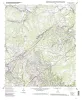
Geologic map of the Kerrville quadrangle, Texas | 2004 | Collins, E.W. | Open-File Map | Bureau of Economic Geology | |
|
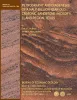
Petrography and diagenesis of a half-billion-year-old cratonic sandstone (Hickory), Llano region, Texas | 2002 | We studied the Hickory Sandstone Member of the Riley Formation, Central Texas, to assess the diagenetic history of a cratonic sandstone, which, in spite of its great age, remains porous and permeable where it has not been buried more than 1 km. |
McBride, E.F., Abdel-Wahab, A.A., Milliken, K.L. | Report of Investigations | Bureau of Economic Geology |
|
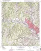
Geologic map of the Cypress Creek quadrangle, Texas | 2002 | Collins, E.W. | Open-File Map | Bureau of Economic Geology | |
|
Geologic map of the Driftwood quadrangle, Texas | 2002 | Collins, E.W. | Open-File Map | Bureau of Economic Geology | |
|
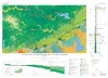
Geologic Map of the New Braunfels, Texas, 30x60 Minute Quadrangle | 2000 | Collins, E.W. | Miscellaneous Map | Bureau of Economic Geology |