Publications in Kerr
| Title | Publication Year Sort ascending | Abstract | Author | Series | Publisher | |
|---|---|---|---|---|---|---|
|
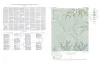
Geologic map of the Klein Branch quadrangle, Gillespie and Kerr Counties, Texas | 1954 | Barnes, V.E. | Geologic Quadrangle Map | Bureau of Economic Geology | |
|
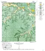
Geologic map of the Morris Ranch quadrangle, Gillespie and Kerr Counties, Texas | 1952 | Barnes, V.E. | Geologic Quadrangle Map | Bureau of Economic Geology | |

|
Geologic map of the Bear Creek quadrangle, Gillespie, Kerr, and Kendall Counties, Texas | 1952 | Barnes, V.E. | Geologic Quadrangle Map | Bureau of Economic Geology |