Publications in Kendall
| Title | Publication Year Sort ascending | Abstract | Author | Series | Publisher | |
|---|---|---|---|---|---|---|
|
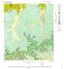
Geology of the Hye Quadrangle, Blanco, Gillespie, and Kendall Counties, Texas | 1965 | Hye quadrangle includes part of the southeastern Llano region and part of the eastern margin of the Edwards Plateau where most of the Plateau surface has been destroyed by erosion. |
Barnes, V.E. | Geologic Quadrangle Map | Bureau of Economic Geology |
|
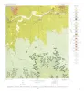
Geology of the Stonewall Quadrangle, Gillespie and Kendall Counties, Texas | 1965 | Stonewall quadrangle includes part of the southern margin of the Llano region and part of the eastern margin of the Edwards Plateau where most of the plateau suriace has been destroyed by erosion. |
Barnes, V.E. | Geologic Quadrangle Map | Bureau of Economic Geology |
| |
Map showing correlation of geologic, gravity, and magnetic observations, Blanco and Gillespie Counties, Texas | 1955 | Barnes, V.E., Romberg, Frederick, Anderson, W.A. | Miscellaneous Map | Bureau of Economic Geology | |

|
Geologic map of the Bear Creek quadrangle, Gillespie, Kerr, and Kendall Counties, Texas | 1952 | Barnes, V.E. | Geologic Quadrangle Map | Bureau of Economic Geology | |
|
Geologic map of the Cain City quadrangle, Gillespie and Kendall Counties, Texas | 1952 | Cain City quadrangle is south of the Llano region and is in the marginal portion of the Edwards Plateau where much of the plateau surface has been destroyed by erosion. Northeastward-trending lobes and outliers of the Edwards Plateau are present in the southern part. |
Barnes, V.E. | Geologic Quadrangle Map | Bureau of Economic Geology |
|
Geologic map of the Stonewall quadrangle, Gillespie and Kendall Counties, Texas | 1952 | Stonewall quadrangle is south of the Llano region and is in the marginal portion of the Edwards Plateau where much of the plateau surface has been destroyed by erosion. |
Barnes, V.E. | Geologic Quadrangle Map | Bureau of Economic Geology |
|
Igneous rocks of the Balcones fault region of Texas | 1927 | Lonsdale, J.T. | UT Bulletin |