Publications in Falls
| Title | Publication Year Sort ascending | Abstract | Author | Series | Publisher | |
|---|---|---|---|---|---|---|
|
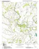
Geologic map of the Baileyville quadrangle, Texas | 2006 | Collins, E.W. | Open-File Map | Bureau of Economic Geology | |
|
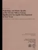
Hydrology and water quality of the Eocene Wilcox Group: significance for lignite development in East Texas | 1980 | Lignite development will place major demands on ground-water supplies. |
Henry, C.D., Basciano, J.M., Duex, T.W. | Geological Circular | Bureau of Economic Geology |

|
Environmental geology of the Wilcox Group lignite belt, east Texas | 1979 | This report provides a data base for decisions about lignite mining and reclamation in the Wilcox Group of East Texas. Kaiser (1974, 1978) estimates that about 12.2 billion short tons of potentially strip-minable lignite resources occur in East and South Texas. |
Henry, C.E., Basciano, J.M. | Report of Investigations | Bureau of Economic Geology |
|
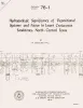
Hydrogeologic significance of depositional systems and facies in Lower Cretaceous sandstones, north-central Texas | 1976 | The Lower Cretaceous Hosston and Hensel Sandstones are important sources of ground water in North-Central Texas. |
Hall, W.D. | Geological Circular | Bureau of Economic Geology |
|
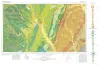
Geologic Atlas of Texas, Waco sheet | 1970 | Geologic maps that depicts the surface geology of McLennan, Limestone, and Falls Counties and parts of Bosque, Hill, Navarro, Freestone, Leon, Madison, Robertson, Milam, Bell, Lampasas, Coryell, and Hamilton Counties, Texas. |
Barnes, V.E., Humble Oil and Refining Co., Shell Oil Co., Mobil Oil Co., Proctor, C.V., Jr., McGowen, J.H., Haenggi, W.T., Hayward, O.T. | Geologic Atlas of Texas | Bureau of Economic Geology |
|
Geology of the Blacklands Experimental Watershed, near Waco, Texas | 1952 | The Blacklands Experimental Watershed, a hydrologic research project of the Soil Conservation Service located about 15 miles southeast of Waco, Texas, is underlain by marls and chalks belonging to the Taylor group of the Gulf series of the Cretaceous system, which, in conformity with the general |
Lonsdale, J.T. | Report of Investigations | Bureau of Economic Geology |
|
Report on a River Terrace Investigation as a Part of a Mineral Resource Survey in Falls County, Texas | 1936 | A mineral resource survey of Texas has been started by the Works Progress Administration, with the Bureau of Economic Geology of The University of Texas acting as sponsor. The purpose of the survey is to assemble information and make it available to the public. |
Hatch, J. | Mineral Resource Survey Circulars | |
|
Some Well Records in Falls County Texas | 1929 | These circulars issued from the Bureau of Economic Geology contain the record of cores and cuttings from well received and described in the Bureau. |
Well Record | ||
|
The geology of east Texas | 1918 | Dumble, E.T. | UT Bulletin |