Publications in Ector
| Title | Publication Year Sort ascending | Abstract | Author | Series | Publisher | |
|---|---|---|---|---|---|---|

|
Hydrogeology and hydrochemistry of the Ogallala aquifer, southern High Plains, Texas panhandle and eastern New Mexico | 1988 | The Ogallala aquifer, which underlies the Southern High Plains, consists of the saturated sediments of the Neogene Ogallala Formation. The aquifer is the main source of water for the High Plains of Texas and New Mexico and is being severely depleted by extensive pumpage for irrigation. |
Nativ, Ronit | Report of Investigations | Bureau of Economic Geology |
|
Bouguer gravity Atlas of Texas, Hobbs sheet | 1986 | This folded transparent map is at the same scale as its corresponding Geologic Atlas of Texas (GAT) sheet and can be superimposed on it to compare gravity information with surface geology. |
Keller, G.R., Aiken, C.L.V. | Bouguer Gravity Atlas of Texas | Bureau of Economic Geology |
|
Regional cross sections -- central basin platform, West Texas | 1985 | In 1982, the Bureau of Economic Geology initiated a project to characterize the major oil fields of Texas. |
Bebout, D.G., Meador, K.J. | Cross Sections | |
|
Genesis and emplacement of oil in the San Andreas Formation, northern shelf of the Midland basin, Texas | 1982 | San Andres oil constitutes more than 80 percent of the total production from the Northern Shelf of the Midland Basin, Texas. |
Ramondetta, P.J. | Report of Investigations | Bureau of Economic Geology |
|
Facies and stratigraphy of the San Andreas Formation, northern and northwestern shelves of the Midland basin, Texas and New Mexico | 1982 | The San Andres Formation on the Northern and Northwestern Shelves of the Midland Basin is a progradational stratigraphic unit consisting predominantly of carbonate facies. Lithofacies include dolomite, laminated anhydrite and dolomite, massive bedded anhydrite, limestone, salt, and red beds. |
Ramondetta, P.J., Guetzow, D.D., Dauzat, Rick, Merritt, R.M., Garza, John, Holman, Lee, Roques, Dominick | Report of Investigations | Bureau of Economic Geology |
|
Depositional framework of the Lower Dockum Group (Triassic), Texas panhandle | 1979 | The Upper Triassic Dockum Group of Texas and New Mexico is composed of 200 to 2,000 feet of complexly interrelated terrigenous clastic facies ranging from mudstone to conglomerate. |
McGowen, J.H., Granata, G.E., Seni, S.J. | Report of Investigations | Bureau of Economic Geology |
|
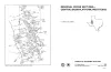
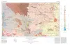
Geologic Atlas of Texas, Hobbs sheet | 1976 | Geologic map that depicts the surface geology of Gaines and Andrews Counties and parts of Yoakum, Terry, Dawson, Martin, Winkler, Ector, and Midland Counties, Texas. The 5-page booklet indicates geologic formations, abbreviations, and ages. |
Barnes, V.E., Eifler, G.K., Reeves, C.C., Kottlowski, F.E., Norman, D.M., Sherrod, C.H., Hansen, J.J. | Geologic Atlas of Texas | Bureau of Economic Geology |

|
Geologic Atlas of Texas, Pecos sheet | 1976 | Geologic map that depicts the surface geology of Loving, Crane, and Ward Counties and parts of Ector, Midland, Upton, Pecos, Reeves, Crockett, and Winkler Counties, Texas. The 5-page booklet indicates geologic formations, abbreviations, and ages. |
Barnes, V.E., Eifler, G.K., Shell Oil Co., Cities Service Petroleum Co., Brown, J.B. | Geologic Atlas of Texas | Bureau of Economic Geology |
|
Occurrence of Oil and Gas in West Texas | 1957 | Herald, F.A. | UT Publication | ||
|
Subsurface Woodford black shale, West Texas and southeast New Mexico | 1950 | The geographic distribution, lithology, thickness, and paleontology of the subsurface Woodford in the Permian basin are described and illustrated. |
Ellison Jr., S.P. | Report of Investigations | Bureau of Economic Geology |