Publications in Duval
| Title | Publication Year Sort ascending | Abstract | Author | Series | Publisher | |
|---|---|---|---|---|---|---|
|
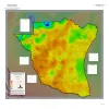
Geothermal Resources, South Texas | 2024 | A series of two 1:500,000 scale maps showing the Geothermal resources of South Texas. |
Andrews, J.R. | Open-File Map | Bureau of Economic Geology |
|
Seismic analysis of the Duval County Ranch area, south Texas: assessment of exploration potential of the Wilcox, Queen City, and Jackson-Yegua plays | 1995 | Potential for commercial hydrocarbon accumulations in Eocene and older strata of the Duval County Ranch in South Texas was assessed using seismic data. Three seismic facies are recognized and tied to well control. |
Fiduk, J.C., Hamilton, D.S. | Geological Circular | Bureau of Economic Geology |
|
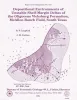
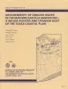
Increased Oil Recovery Potential from Barrier/Strandplain Reservoirs, Jackson-Yegua Trend, by Geologically Targeted Infill Drilling: Examples from Seventy-Six West and Colmena-Cedro Hill Fields, South Texas | 1994 | The Jackson-Yegua Barrier/Strandplain Sandstone play is a prolific oil-producing trend in South Texas that has high average porosity (31 percent) and permeability (600 md). |
Hamilton, D.S. | Report of Investigations | Bureau of Economic Geology |
|
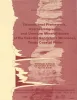
Depositional Environments of Unstable Shelf-Margin Deltas of the Oligocene Vicksburg Formation, McAllen Ranch Field, South Texas | 1994 | Cores and supporting petrophysical data from 20 wells in McAllen Ranch field were analyzed. |
Langford, R.P., Combes, J.M. | Report of Investigations | Bureau of Economic Geology |
|
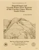
Depositional and ground-water flow systems of the Carrizo - Upper Wilcox, south Texas | 1988 | In the Rio Grande Embayment of South Texas, the Carrizo Formation (lower Eocene) consists of two sand-rich fluvial depositional systems that grade basinward into several deltaic complexes within the upper part of the Wilcox Group. |
Hamlin, H.S. | Report of Investigations | Bureau of Economic Geology |
|
Depositional framework, hydrostratigraphy, and uranium mineralization of the Oakville Sandstone (Miocene), Texas coastal plain | 1982 | The Oakville Sandstone (Miocene) of the Texas Coastal Plain comprises a major sand-rich fluvial system composed of deposits of several major and minor rivers that originated within Texas and surrounding states. |
Galloway, W.E., Henry, C.D., Smith, G.E. | Report of Investigations | Bureau of Economic Geology |
|
Geochemistry of ground water in the Miocene Oakville Sandstone -- a major aquifer and uranium host of the Texas coastal plain | 1982 | The Oakville Sandstone is a major aquifer and a major host of uranium deposits in the Texas Coastal Plain. |
Henry, C.D., Galloway, W.E., Smith, G.E., Ho, C.L., Morton, J.P., Gluck, J.K. | Report of Investigations | Bureau of Economic Geology |
|
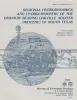
Regional hydrodynamics and hydrochemistry of the uranium-bearing Oakville aquifer (Miocene) of south Texas | 1982 | The Oakville Formation consists of sediments deposited by several major fluvial systems that traversed the Texas Coastal Plain during the Miocene Epoch. |
Smith, G.E., Galloway, W.E., Henry, C.D., Gluck, J.K., McIntyre, J.F., Pisasale, E.T., Spradlin, S.D. | Report of Investigations | Bureau of Economic Geology |
|
Considerations in the extraction of uranium from a fresh-water aquifer -- Miocene Oakville Sandstone, south Texas | 1982 | The Miocene Oakville Sandstone is a major aquifer and uranium host beneath the Texas Coastal Plain. In 1976, approximately 6,000 acre-ft of ground water were withdrawn from the Oakville for municipal use. |
Henry, C.D., Galloway, W.E., Smith, G.E., Childs, C.S., Devine, P.E., Dutton, A.R., Gluck, J.K., McIntyre, J.F. | Report of Investigations | Bureau of Economic Geology |

|
Structural cross sections, Tertiary formations, Texas Gulf Coast | 1981 | The publication comprises 24 structural dip cross sections, spaced 15 to 20 mi apart along the Texas coast, and 4 structural strike cross sections. Dip sections extend from near the Wilcox outcrop to the coastline. |
Dodge, M.M., Posey, J.S. | Cross Sections | Bureau of Economic Geology |