Publications in Coryell
| Title | Publication Year Sort ascending | Abstract | Author | Series | Publisher | |
|---|---|---|---|---|---|---|
|
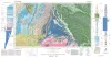
Geologic Atlas of Texas, Brownwood sheet | 1976 | Geologic map that depicts the surface geology of Mills County and parts of Runnels, Coleman, Brown, Comanche, Erath, Hamilton, Coryell, Lampasas, San Saba, McCulloch, Concho, and Menard Counties. The 21-page booklet indicates geologic formations, abbreviations, and ages. |
Kier, R.S., Harwood, P., Brown, L.F., Jr., Goodson, J.L., Barnes, V.E., Shell Oil Co., Humble Oil and Refining Co., Southern Minerals Corp. | Geologic Atlas of Texas | Bureau of Economic Geology |
|
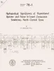
Hydrogeologic significance of depositional systems and facies in Lower Cretaceous sandstones, north-central Texas | 1976 | The Lower Cretaceous Hosston and Hensel Sandstones are important sources of ground water in North-Central Texas. |
Hall, W.D. | Geological Circular | Bureau of Economic Geology |
|
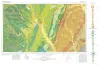
Geologic Atlas of Texas, Waco sheet | 1970 | Geologic maps that depicts the surface geology of McLennan, Limestone, and Falls Counties and parts of Bosque, Hill, Navarro, Freestone, Leon, Madison, Robertson, Milam, Bell, Lampasas, Coryell, and Hamilton Counties, Texas. |
Barnes, V.E., Humble Oil and Refining Co., Shell Oil Co., Mobil Oil Co., Proctor, C.V., Jr., McGowen, J.H., Haenggi, W.T., Hayward, O.T. | Geologic Atlas of Texas | Bureau of Economic Geology |
|
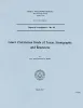
Lower Cretaceous sands of Texas: stratigraphy and resources | 1967 | Lower Cretaceous sands have long been important aquifers in Central, North-Central, and North Texas. In recent years these sands also have been sources of high-silica industrial or specialty-purpose sand. |
Fisher, W.L., Rodda, P.U. | Report of Investigations | Bureau of Economic Geology |
|
Nomenclature revision of basal Cretaceous rocks between the Colorado and Red Rivers, Texas | 1966 | Based on need for convenient, small-scale cartographic units, the basal Cretaceous rocks in Texas from Red River to Burnet County and on the Callahan Divide are herein divided into three distinctive lithologic sequences. |
Fisher, W.L., Rodda, P.U. | Report of Investigations | Bureau of Economic Geology |
|
Stratigraphy of the Fredericksburg Division, south-central Texas | 1964 | Sediments of the Fredericksburg Division in south-central Texas were deposited on the slowly subsiding west flank of the Tyler basin. In this region there are three stratigraphically distinct areas. The southern area has a thick Edwards Limestone unit overlying a thin Walnut Formation. |
Moore, C.H. | Report of Investigations | Bureau of Economic Geology |
|
Symposium on Edwards Limestone in Central Texas | 1959 | Lozo, F.E., Nelson, H.F., Young, Keith, Shelburne, O.B., Sandidge, J.R. | UT Publication | ||
|
Stratigraphy of the Pennsylvanian Formations of north-central Texas | 1921 | Plummer, F.B., Moore, R.C. | UT Bulletin | ||
|
On the underground position of the Ellenburger Formation in north central Texas, with a preliminary contour map | 1918 | Sellards, E.H. | UT Bulletin |