Publications in Clay
| Title | Publication Year Sort ascending | Abstract | Author | Series | Publisher | |
|---|---|---|---|---|---|---|
|
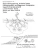
Regional depositional systems tracts, paleogeography, and sequence stratigraphy, Upper Pennsylvanian and Lower Permian strata, north- and west-central Texas | 1990 | Sixteen depositional sequences, commonly called cyclothems, each composed mostly of limestone(retrogradational/transgressive) and siliciclastic (progradational/regressive) subsequences, or systems tracts, record the paleogeography during Late Pennsylvanian (Virgilian Epoch) and Early Permian (Wol |
Brown, L.F., Jr., Solis-Iriarte, R.F., Johns, D.A. | Report of Investigations | Bureau of Economic Geology |
|
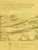
Lithostratigraphy and paleoenvironments of Upper Paleozoic continental red beds, north-central Texas: Bowie (new) and Wichita (revised) Groups | 1988 | Approximately 2,200 ft (670 m) of principally continental and paralic rocks of late Virgilian, Wolfcampian, and early Leonardian age (late Pennsylvanian and early Permian) are exposed in an area of about 4,950 mi2 (12,800 km2) between the Brazos and Red Rivers in North-Central Texas. |
Hentz, T.F. | Report of Investigations | Bureau of Economic Geology |
|
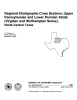
Regional stratigraphic cross sections, Upper Pennsylvanian and Lower Permian strata (Virgilian and Wolfcampian Series), north-central Texas | 1987 | This cross section set comprises 14 dip (E-W) sections and 9 strike (N-S) stratigraphic cross sections (with text), correlating upper Pennsylvanian (Virgilian) and lower Permian (Wolfcampian) strata throughout the subsurface in all or parts of 28 counties of North-Central Texas. |
Brown, L.F., Jr., Solis-Iriarte, R.F., Johns, D.A. | Cross Sections | |
|
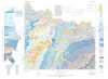
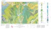
Geologic Atlas of Texas, Wichita Falls-Lawton sheet | 1987 | Geologic map that depicts the surface geology of Hardeman, Wilbarger, Wichita, Clay, Knox, Baylor, Archer, Haskell, Throckmorton, Young, and Foard Counties and part of Jack County, Texas. The 20-page booklet indicates geologic formations, abbreviations, and ages. |
Barnes, V.E., Hentz, T.F., Brown, L.F., Jr., Cleaves, A.W., Kier, R.S., McGowen, J.H., Parrish, W.C., Ramsey, J.W. | Geologic Atlas of Texas | Bureau of Economic Geology |
|
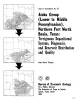
Atoka Group (Lower to Middle Pennsylvanian), northern Fort Worth basin, Texas: terrigenous depositional systems, diagenesis, and reservoir distribution and quality | 1982 | The Fort Worth Basin, in North-Central Texas, is a late Paleozoic foreland basin that was downwarped during the Early to Middle Pennsylvanian Period in response to tectonic stresses that also produced the Ouachita Thrust Belt. |
Thompson, D.M. | Report of Investigations | Bureau of Economic Geology |
|
The Mississippian and Pennsylvanian (Carboniferous) Systems in the United States -- Texas | 1980 | Kier, R.S., Brown, L.F., Jr., McBride, E.F. | Geological Circular | Bureau of Economic Geology | |
|
Depositional systems in Canyon Group (Pennsylvanian System), north-central Texas | 1975 | The Canyon Group (Missourian Series) is a sequence of westward-dipping, genetically related carbonate and terrigenous clastic facies that crop out in a northeast-southwest belt across North-Central Texas. |
Erxleben, A.W. | Report of Investigations | Bureau of Economic Geology |
|
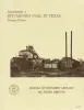
Bituminous coal in Texas | 1974 | Coal is found in six areas in Texas, including the large North-Central Texas field, a distinctive cannel coalfield in Webb County, and Late Cretaceous-age coals near Eagle Pass. |
Evans, T.J. | Handbook | Bureau of Economic Geology |
|
Lower Cretaceous sands of Texas: stratigraphy and resources | 1967 | Lower Cretaceous sands have long been important aquifers in Central, North-Central, and North Texas. In recent years these sands also have been sources of high-silica industrial or specialty-purpose sand. |
Fisher, W.L., Rodda, P.U. | Report of Investigations | Bureau of Economic Geology |
|
Geologic Atlas of Texas, Sherman sheet (revised 1991) | 1967 | Geologic map that depicts the surface geology of Montague, Cooke, Grayson, Wise, Denton, and Collin Counties and parts of Jack, Fannin, Hunt, and Clay Counties, Texas. The 16-page booklet indicates geologic formations, abbreviations, and ages. |
McGowen, J.H., Hentz, T.F., Owen, D.E., Pieper, M.K., Shelby, C.A., Barnes, V.E., Humble Oil and Refining Co., Pure Oil Co. | Geologic Atlas of Texas | Bureau of Economic Geology |