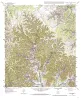
|
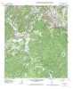
Geologic map of the Sabinal Canyon quadrangle, Texas |
1999 |
|
Collins, E.W. |
Open-File Map |
Bureau of Economic Geology |
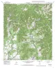
|
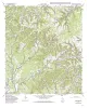
Geologic map of the Seco Pass Quadrangle, Texas |
1999 |
|
Collins, E.W. |
Open-File Map |
Bureau of Economic Geology |

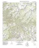
|
Geologic map of the Bandera quadrangle, Texas |
1997 |
|
Collins, E.W. |
Open-File Map |
Bureau of Economic Geology |
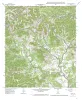
|
Geologic map of the Tarpley Pass Quadrangle, Texas |
1997 |
|
Collins, E.W. |
Open-File Map |
Bureau of Economic Geology |
|
Geologic map of the Tarpley Quadrangle, Texas |
1997 |
|
Collins, E.W. |
Open-File Map |
Bureau of Economic Geology |
|
Geologic map of the Timber Creek Quadrangle, Texas |
1997 |
|
Collins, E.W. |
Open-File Map |
Bureau of Economic Geology |

|
Geologic map of the Twin Hollow Quadrangle, Texas |
1997 |
|
Collins, E.W. |
Open-File Map |
Bureau of Economic Geology |
|
Geologic map of the Turkey Knob quadrangle, Texas |
1995 |
|
Collins, E.W. |
Open-File Map |
Bureau of Economic Geology |
|
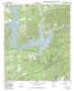
Geologic map of the Ranger Creek Quadrangle, Texas |
1995 |
|
Collins, E.W. |
Open-File Map |
Bureau of Economic Geology |
|
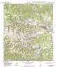
Geologic map of the Medina Lake Quadrangle, Texas |
1995 |
|
Collins, E.W. |
Open-File Map |
Bureau of Economic Geology |