Publications in Atascosa
| Title | Publication Year Sort ascending | Abstract | Author | Series | Publisher | |
|---|---|---|---|---|---|---|
|
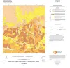
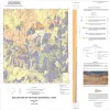
Geologic map of the Rossville quadrangle, Texas | 2019 | Elliott, Brent A. | Open-File Map | Bureau of Economic Geology | |
|
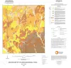
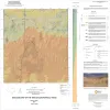
Geologic map of the Leming quadrangle, Texas | 2019 | Elliott, Brent A. | Open-File Map | Bureau of Economic Geology | |
|
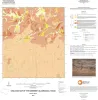
Geologic map of the Somerset quadrangle, Texas | 2018 | Elliott, Brent A. | Open-File Map | Bureau of Economic Geology | |
|
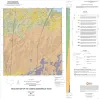
Geologic map of the Losoya quadrangle, Texas | 2014 | Elliott, Brent A. | Open-File Map | Bureau of Economic Geology | |
|
Geologic map of the Poteet quadrangle, Texas | 2013 | Elliott, Brent A. | Open-File Map | Bureau of Economic Geology | |
|
Geologic map of the Thelma quadrangle, Texas | 2013 | Elliott, Brent A. | Open-File Map | Bureau of Economic Geology | |
|
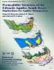
Permeability structure of the Edwards aquifer, south Texas -- implications for aquifer management | 1998 | This report describes the three-dimensional distribution of hydraulic conductivity in the Edwards aquifer from Kinney to Comal Counties, Texas. |
Hovorka, S.D., Mace, R.E., Collins, E.W. | Report of Investigations | Bureau of Economic Geology |
|
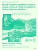
Edwards aquifer ground-water resources: geologic controls on porosity development in platform carbonates, south Texas | 1996 | Focusing on the highly developed Edwards aquifer, which supplies water for a large area of south-central Texas, this report presents a three-dimensional model of the porosity distribution in the aquifer, which quantifies the spatial distribution of water resources and provides information that ca |
Hovorka, S.D., Dutton, A.R., Ruppel, S.C., Yeh, J.S. | Report of Investigations | Bureau of Economic Geology |
|
Depositional and ground-water flow systems of the Carrizo - Upper Wilcox, south Texas | 1988 | In the Rio Grande Embayment of South Texas, the Carrizo Formation (lower Eocene) consists of two sand-rich fluvial depositional systems that grade basinward into several deltaic complexes within the upper part of the Wilcox Group. |
Hamlin, H.S. | Report of Investigations | Bureau of Economic Geology |
|
Depositional systems and oil and gas plays in the Cretaceous Olmos Formation, south Texas | 1986 | The Upper Cretaceous Olmos Formation in South Texas continues to be an active exploration target 60 years after oil was first discovered in this clastic assemblage. The shallow, oil-bearing formation was deposited on a broad, wave-influenced shelf. Sand accumulated in two depocenters. |
Tyler, Noel, Ambrose, W.A. | Report of Investigations | Bureau of Economic Geology |