Publications by Hovorka, S.D.
| Title | Publication Year Sort ascending | Abstract | Author | Series | Publisher | |
|---|---|---|---|---|---|---|

|
Carbon-nots to the Rescue! | 2025 | The Carbon-nots to the Rescue comic book was initially designed as supplemental material to help middle school science teachers explain new concepts within revised state educational standards for Texas students, known as Texas Essential Knowledge and Skills (TEKS). |
van der Kolk, D.A., Mastrangelo, F.M., Hovorka, S.D., Tran, V.H., Luciano, A.K. | Coloring and Comic Books | Bureau of Economic Geology |
|
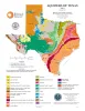
Aquifers of Texas | 2001 | Hovorka, S.D. | Thematic Maps | Bureau of Economic Geology | |
|
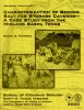
Characterization of bedded salt for storage caverns -- a case study from the Midland Basin, Texas | 2000 | The geometry of Permian bedded salt in the Midland Basin is a product of the interaction between depositional facies and postdepositional modification by salt dissolution. |
Hovorka, S.D. | Geological Circular | Bureau of Economic Geology |
|
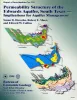
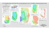
Permeability structure of the Edwards aquifer, south Texas -- implications for aquifer management | 1998 | This report describes the three-dimensional distribution of hydraulic conductivity in the Edwards aquifer from Kinney to Comal Counties, Texas. |
Hovorka, S.D., Mace, R.E., Collins, E.W. | Report of Investigations | Bureau of Economic Geology |
|
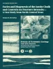
Facies and diagenesis of the Austin Chalk and controls on fracture intensity -- a case study from north-central Texas | 1998 | The urban corridors associated with the Dallas, Austin, and San Antonio metropolitan areas lie on Austin Chalk outcrop. In these areas of rapid urbanization, ground-water information is needed to resolve environmental issues. The Austin Chalk also produces hydrocarbons in the deep subsurface. |
Hovorka, S.D. | Geological Circular | Bureau of Economic Geology |
|
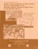
Structure Map of the San Antonio Segment of the Edwards Aquifer and Balcones Fault Zone, South-Central Texas: Structural Framework of a Major Limestone Aquifer: Kinney, Uvalde, Medina, Bexar, Comal, and Hays Counties | 1997 | Collins, E.W., Hovorka, S.D. | Miscellaneous Map | Bureau of Economic Geology | |
|
Salt Thickness and Other Geologic Factors Important to Salt Caverns in the Midland Basin, Texas - Poster | 1997 | Hovorka, S.D. | Posters | Bureau of Economic Geology | |
|
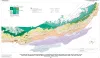
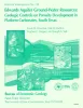
Edwards aquifer ground-water resources: geologic controls on porosity development in platform carbonates, south Texas | 1996 | Focusing on the highly developed Edwards aquifer, which supplies water for a large area of south-central Texas, this report presents a three-dimensional model of the porosity distribution in the aquifer, which quantifies the spatial distribution of water resources and provides information that ca |
Hovorka, S.D., Dutton, A.R., Ruppel, S.C., Yeh, J.S. | Report of Investigations | Bureau of Economic Geology |
|
Origin and development of playa basins, sources of recharge to the Ogallala aquifer, southern High Plains, Texas and New Mexico | 1995 | More than 20,000 playa basins have formed on the Southern High Plains of Texas and New Mexico. |
Gustavson, T.C., Holliday, V.T., Hovorka, S.D. | Report of Investigations | Bureau of Economic Geology |
|
Chert reservoir development in the Devonian Thirtyone Formation: Three Bar field, West Texas | 1995 | Chert reservoirs of the Lower Devonian Thirtyone Formation represent a substantial part of the hydrocarbon resource in the Permian Basin. More than 700 million barrels of oil has been produced from these rocks, and an equivalent amount of mobile oil remains. |
Ruppel, S.C., Hovorka, S.D. | Report of Investigations | Bureau of Economic Geology |