Publications by Gustavson, T.C.
| Title | Publication Year Sort ascending | Abstract | Author | Series | Publisher | |
|---|---|---|---|---|---|---|
|
Fluvial and eolian depositional systems, paleosols, and paleoclimate of the Upper Cenozoic Ogallala and Blackwater Draw Formations, southern High Plains, Texas and New Mexico | 1996 | This report summarizes results of a study based on outcrop and subsurface data that establishes a regional stratigraphic framework for assessments of the Ogallala and related aquifers. |
Gustavson, T.C. | Report of Investigations | Bureau of Economic Geology |
|
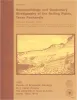
Origin and development of playa basins, sources of recharge to the Ogallala aquifer, southern High Plains, Texas and New Mexico | 1995 | More than 20,000 playa basins have formed on the Southern High Plains of Texas and New Mexico. |
Gustavson, T.C., Holliday, V.T., Hovorka, S.D. | Report of Investigations | Bureau of Economic Geology |
|
Geophysical and Geochemical Delineation of Sites of Saline-Water Inflow to the Canadian River, New Mexico and Texas | 1994 | Lake Meredith, which supplies water for domestic use to all major Texas cities on the Southern High Plains, exceeds State of Texas limits for chloride and sulfate content. |
Paine, J.G., Avakian, A.J., Gustavson, T.C., Hovorka, S.D., Richter, B.C. | Report of Investigations | Bureau of Economic Geology |
|
Arid basin depositional systems and paleosols: Fort Hancock and Camp Rice Formations (Pliocene-Pleistocene), Hueco Bolson, West Texas and adjacent Mexico | 1991 | The Hueco Bolson is a segment of the Rio Grande Rift that formed as a result of late Tertiary Basin and Range deformation. The upper Tertiary Fort Hancock Formation and the upper Tertiary-Quaternary Camp Rice Formation compose the basin fill except in the deepest (western) parts of the bolson. |
Gustavson, T.C. | Report of Investigations | Bureau of Economic Geology |
|
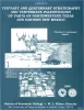
Tertiary and Quaternary stratigraphy and vertebrate paleontology of parts of northwestern Texas and eastern New Mexico | 1990 | This field guide summarizes recent interpretations of the upper Cenozoic stratigraphy of parts of the Southern High Plains and Rolling Plains in northwestern Texas and eastern New Mexico. |
Gustavson, T.C., Holliday, V.T., Osterkamp, W.R., Schultz, G.E., Winkler, D.A. | Guidebook | Bureau of Economic Geology |
|
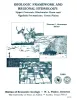
Geologic Framework and Regional Hydrology: Upper Cenozoic Blackwater Draw and Ogallala Formations, Great Plains | 1990 | Gustavson, T.C. | Symposia | Bureau of Economic Geology | |
|
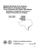
Regional structural cross sections, mid-Permian to Quaternary strata, Texas panhandle and eastern New Mexico: distribution of evaporites and areas of evaporite dissolution and collapse | 1988 | The Palo Duro Basin of the Texas Panhandle and eastern New Mexico contains bedded Permian salts of sufficient thickness and depth for the basin to be considered as a potential site for long-term storage and isolation of high-level nuclear waste. |
McGookey, D.A., Gustavson, T.C., Hoadley, A.D. | Cross Sections | Bureau of Economic Geology |
|
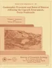
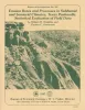
Geomorphic processes and rates of retreat affecting the Caprock Escarpment, Texas panhandle | 1988 | The interaction of geomorphic and ground-water processes has produced the Caprock Escarpmentthat bounds the eastern margin of the Southern High Plains in the Texas Panhandle. |
Gustavson, T.C., Simpkins, W.W. | Report of Investigations | Bureau of Economic Geology |
|
Erosion rates and processes in subhumid and semiarid climates, Texas panhandle: statistical evaluation of field data | 1987 | Since 1978, six climate- and erosion-monitoring stations on slopes in draws and large playa lake basins in the interior of the Southern High Plains and slopes along the Caprock Escarpment in the Rolling Plains of the Texas Panhandle have recorded precipitation amount and intensity, air and soil t |
Simkins, W.W., Gustavson, T.C. | Report of Investigations | Bureau of Economic Geology |
|
Geomorphology and Quaternary stratigraphy of the Rolling Plains, Texas Panhandle | 1986 | Gustavson, T.C., Baumgardner, R.W., Jr., Caran, S.C., Collins, E.W., Dalquest, W.W., Goldstein, A.G., Harrison, B.R., Machenberg, M.D. | Guidebook | Bureau of Economic Geology |