Publications by Baumgardner, R.W., Jr.
| Title | Publication Year Sort ascending | Abstract | Author | Series | Publisher | |
|---|---|---|---|---|---|---|
|
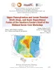
Upper Pennsylvanian and Lower Permian Shelf, Slope, and Basin Depositional Facies of the Southern Eastern Shelf of the Midland Basin: Core Workshop | 2017 | Hentz, T.F., Ambrose, W.A., Palacios, F.C., Baumgardner, R.W., Jr. | Seminars and Workshops | Bureau of Economic Geology | |
|
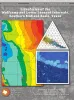
Lithofacies of the Wolfcamp and Lower Leonard Intervals, Southern Midland Basin | 2016 | Basinal mudrocks and associated facies assigned to the Wolfcamp and lower Leonard lithostratigraphic units in the Midland Basin are prolific producers of oil and gas. |
Baumgardner, R.W., Jr., Hamlin, H.S., Rowe, H.D. | Report of Investigations | Bureau of Economic Geology |
|
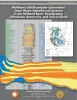
Wolfberry (Wolfcampian-Leonardian) Deep-Water Depositional Systems in the Midland Basin: Stratigraphy, Lithofacies, Reservoirs, and Source Rocks | 2012 | The Wolfberry play in West Texas combines favorable geology with innovative completion practices to form one of the largest unconventional oil plays in the United States. Wolfberry wells produced almost 55 million barrels of oil in 2011, and that figure could double in a few years. |
Hamlin, H.S., Baumgardner, R.W., Jr. | Report of Investigations | Bureau of Economic Geology |
|
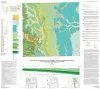
Geologic map of the east part of Cleburne, Texas, 30 x 60 minute quadrangle: South Fort Worth-Interstate 35W corridor | 2011 | Collins, E.W., Baumgardner, R.W., Jr. | Miscellaneous Map | Bureau of Economic Geology | |
|
Surface fissures in the Hueco Bolson and adjacent basins, West Texas | 1992 | Surface fissures have been observed in many desert basins in the western United States. These surface-collapse features are usually discovered after a normally dry surface has been covered with water, either by runoff from intense rainfall, by flooding, or by irrigation. |
Baumgardner, R.W., Jr., Scanlon, B.R. | Geological Circular | Bureau of Economic Geology |
|
Geologic map of the Wimberley Quadrangle, Texas | 1991 | Collins, E.W., Baumgardner, R.W., Jr., Raney, J.A. | Open-File Map | Bureau of Economic Geology | |
|
Geologic map of the Hunter Quadrangle, Texas | 1991 | Baumgardner, R.W., Jr., Collins, E.W. | Open-File Map | Bureau of Economic Geology | |
|
Geologic map of the Sattler quadrangle, Texas | 1991 | Collins, E.W., Baumgardner, R.W., Jr., Raney, J.A. | Open-File Map | Bureau of Economic Geology | |
|
Geologic characterization of low-permeability gas reservoirs, Travis Peak Formation, East Texas | 1991 | The Lower Cretaceous Travis Peak Formation contains an estimated 6.4 trillion cubic feet (Tcf) of gas in place in East Texas and North Louisiana. Advanced technology will be needed to maximize recovery from this low-permeability ("tight") gas sandstone. |
Dutton, S.P., Laubach, S.E., Tye, R.S., Baumgardner, R.W., Jr., Herrington, K.L. | Report of Investigations | Bureau of Economic Geology |
|
Morphometric studies of subhumid and semiarid drainage basins, Texas panhandle and northeastern New Mexico | 1987 | Data from five drainage basins in the Texas Panhandle and northeastern New Mexico characterize the recent history of regional drainage basin formation and landscape development around the margins of the Southern High Plains. |
Baumgardner, R.W., Jr., Mawhorter, J.F., Moustafa, A.R., Myers, R.M., Sandstrom, M.A. | Report of Investigations | Bureau of Economic Geology |