
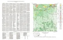
Palo Alto Creek quadrangle is south of the Llano region and is in the marginal portion of the Edwards Plateau where much of the plateau surface has been destroyed by erosion. Along the northern edge of the quadrangle, a portion of a finger of the plateau trends eastward, and in the west-central part, another finger of the plateau frays out into a number of isolated outliers. The rest of the quadrangle is a portion of the gently undulating broad Pedernales River basin.
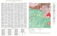
Chemical analyses show that a reef approximately 100 feet thick in the lower portionof the Marble Falls limestone near Marble Falls, Burnet County, Texas, is exceptionally pure. Only the Honeycut formation, of the other formations described, contains limestone that might be of value.The type section of the Marble Falls limestone is described, including thin-section and insoluble residue descriptions.
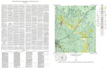
Stonewall quadrangle is south of the Llano region and is in the marginal portion of the Edwards Plateau where much of the plateau surface has been destroyed by erosion. Along the southern edge, lobes of the Edwards Plateau are present, which coalesce southward to form a continuous narrow east-west plateau belt � part of which is just south of the Stonewall quadrangle. Most of the quadrangle is within the gently undulating, broad Pedernales River basin.
The Blacklands Experimental Watershed, a hydrologic research project of the Soil Conservation Service located about 15 miles southeast of Waco, Texas, is underlain by marls and chalks belonging to the Taylor group of the Gulf series of the Cretaceous system, which, in conformity with the general structure of the Gulf Coastal Plain, dip east-southeastward at an angle a little steeper than the general slope of the land surface.The lowest strata cropping out in the experimental watershed are part of the Wolfe City member of the Taylor marl and consist of about 110 feet of sandy marl containing