
A preliminary study of the Frio sand distribution and formation temperatures and pressures was undertaken in order to define prospective areas in which a more detailed reservoir analysis is necessary prior to the selection of a site for a geothermal well.
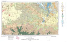
Geologic map that depicts the surface geology of Borden, Scurry, Fisher, Martin, Howard, Mitchell, and Nolan Counties and parts of Glasscock, Sterling, Coke, Runnels, Taylor, Jones, Dawson, Martin, Lynn, Garza, Kent, and Stonewall Counties. The 6-page booklet indicates geologic formations, abbreviations, and ages.
The stratigraphic record yields evidence that each episode of clastic silicate deposition has been of limited duration and that each has been preceded and followed by a significant hiatus. Evidence for alternations of deposition and nondeposition is readily apparent in the landward portions of Pleistocene deposits along the Gulf Coast, due to the glacio-eustatic changes in sea level; evidence of alternations, although elusive, exists also in the basinward portions of these deposits.
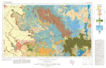
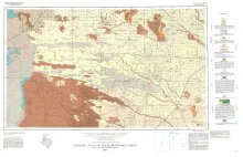
Geologic map that depicts the surface geology of Tom Green, Irion, and Reagan Counties and parts of Midland, Glasscock, Sterling, Coke, Runnels, Concho, Menard, Schleicher, Crockett, and Upton Counties, Texas.
Geologic map that depicts the surface geology of Cochran and Hockley Counties and parts of Bailey, Lamb, Yoakum, Terry, Hale, Lubbock, and Lynn Counties.