The 15-minute Agua Fria quadrangle in southwestern Brewster County, Texas, is arid, sparsely vegetated, and includes diverse topographic features that result chiefly from complex structure and variation in rock resistance to erosion. The mountainous and more complicated southern part of the area has suffered much deformation by igneous intrusions and faulting. The Comanche series is represented by the Devils River limestone, Grayson marl, and Buda limestone.
Rocks of Cretaceous age crop out along the western margins of the deeper playa basins and along the southern and southeastern margins of the Llano Estacado. The Trinity group, containing only the Paluxy sandstone; the Fredericksburg group, consisting of the Walnut, Comanche Peak, Edwards, and Kiamichi formations; and the Washita group, containing only a portion of the Duck Creek formation, have been identified in the Llano Estacado.
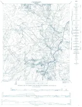
The Tascotal Mesa quadrangle is in southeastern Presidio and southwestern Brewster counties, Trans Pecos Texas. Bandera Mesa and Tascotal Mesa are reached most easily from Marfa, 50 miles north, by the Marfa-Lajitas road which traverses the quadrangle from north to south. Green Valley in the northeastern part of the area is most easily reached from Marfa by the 02 Ranch road in Paradise Valley; an alternate route is from Alpine by the Terlingua highway and the 02 Ranch road.