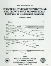
The wide variability in structural styles within the growth-faulted, geopressured trends of the Texas Gulf Coast is illustrated by detailed structural maps of selected areas of the Wilcox and Frio growth-fault trends and quantified by statistical analysis of fault compartment geometries. Structural variability is a key determinant of the size of geopressured aquifers in the deep subsurface.Two major structural styles exist in the Wilcox trend.

The State-owned submerged lands of Texas encompass almost 6,000 mi2 (15,540 km2). They lie below waters of the bay-estuary-lagoon system and the Gulf of Mexico and extend 10.3 mi (16.6 km) seaward from the Gulf shoreline (fig. 1). The importance of these lands and their resources to resident flora and fauna as well as to people is well known and documented; more than one-third of the state's population is concentrated within an area of the Coastal Zone that is only about one-sixteenth of the state's land area.
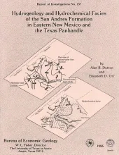
Fluid pressure, permeability, rates and patterns of ground-water flow, and chemical and isotopic composition of ground water in carbonate rock in the lower part of the San Andres Formation (Permian) in eastern New Mexico and the Texas Panhandle were studied to characterize the origin and movement of brine within an evaporite-carbonate-shale confining system.
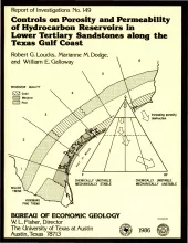
Examination of porosity and permeability (reservoir quality) data, as determined by whole core, acoustic log, and petrographic analyses of lower Tertiary sandstones along the Texas Gulf Coast, made it possible to delineate areas most favorable for development of hydrocarbon reservoirs. Deep (about 3,350 m [11,000 ft] or greater) Wilcox sandstones exhibit no systematic regional reservoir-quality trends. Along the lower and parts of the middle and upper Texas Gulf Coast, deep Wilcox sandstones are tight, but in other parts of the middle and upper Texas Gulf Coast, porosity exists at depth.
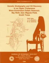
The Big Wells (San Miguel) reservoir in Dimmit and Zavala Counties, South Texas, produces from a broadly lenticular, wave-dominated deltaic sandstone encased in prodelta and shelf mudstones. An updip porosity pinch-out coincides with a gentle undulation on a uniformly gulfward-dipping monocline and forms a structurally modified stratigraphic trap. The reservoir is relatively tight and has average porosity of 21 percent and average permeability of 6 md; wells require fracturing to stimulate production.