Hueco Bolson Publications
| Title | Publication Year Sort ascending | Abstract | Author | Series | Publisher | |
|---|---|---|---|---|---|---|
|
Geologic map of the central Hueco Bolson, Acala - Fort Hancock - Esperanza region, Texas | 2002 | Collins, E.W., Raney, J.A. | Miscellaneous Map | Bureau of Economic Geology | |
|
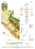
Surface fissures in the Hueco Bolson and adjacent basins, West Texas | 1992 | Surface fissures have been observed in many desert basins in the western United States. These surface-collapse features are usually discovered after a normally dry surface has been covered with water, either by runoff from intense rainfall, by flooding, or by irrigation. |
Baumgardner, R.W., Jr., Scanlon, B.R. | Geological Circular | Bureau of Economic Geology |
|
Arid basin depositional systems and paleosols: Fort Hancock and Camp Rice Formations (Pliocene-Pleistocene), Hueco Bolson, West Texas and adjacent Mexico | 1991 | The Hueco Bolson is a segment of the Rio Grande Rift that formed as a result of late Tertiary Basin and Range deformation. The upper Tertiary Fort Hancock Formation and the upper Tertiary-Quaternary Camp Rice Formation compose the basin fill except in the deepest (western) parts of the bolson. |
Gustavson, T.C. | Report of Investigations | Bureau of Economic Geology |