Copano Bay Publications
| Title | Publication Year Sort ascending | Abstract | Author | Series | Publisher | |
|---|---|---|---|---|---|---|
|
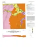
Geologic map of the Rincon Bend quadrangle, Aransas River and Copano Bay area, Texas Gulf of Mexico coast | 2015 | Paine, J.G., Collins, E.W., Costard, L. | Open-File Map | Bureau of Economic Geology | |
|
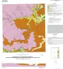
Geologic map of the Woodsboro quadrangle: Aransas and Mission Rivers, and Copano Bay area, Texas Gulf of Mexico Coast | 2015 | Paine, J.G., Collins, E.W., Costard, L. | Open-File Map | Bureau of Economic Geology | |
|
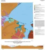
Geologic map of the Bayside quadrangle: Aransas Delta and Copano Bay Area, Texas Gulf of Mexico Coast | 2014 | Paine, J.G., Collins, E.W. | Open-File Map | Bureau of Economic Geology | |
|
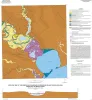
Geologic map of the Mission Bay quadrangle: Mission Delta and Copano Bay area, Texas Gulf of Mexico Coast | 2014 | Paine, J.G., Collins, E.W. | Open-File Map | Bureau of Economic Geology | |
|
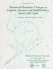
Historical shoreline changes in Copano, Aransas, and Redfish Bays, Texas Gulf coast | 1993 | Shorelines bordering the bays of Texas are generally not as dynamic as those along the Gulf of Mexico. Nevertheless, the predominantly erosional movement of these bay shorelines translates to large losses of wetlands, arable uplands, and recreational and residential property. |
Paine, J.G., Morton, R.A. | Geological Circular | Bureau of Economic Geology |
|
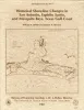
Historical shoreline changes in San Antonio, Espiritu Santo, and Mesquite Bays, Texas Gulf coast | 1987 | Changes in the position and stability of shorelines in the San Antonio Bay system (San Antonio, Espiritu Santo, and Mesquite Bays), Texas Gulf Coast, were documented using historical monitoring techniques. |
White, W.A., Morton, R.A. | Geological Circular | Bureau of Economic Geology |
|
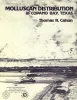
Molluscan Distribution in Copano Bay, Texas | 1980 | Benthic samples were collected on a 1-mi grid from Copano Bay, Texas, in March and April, 1976. Seventy-four molluscan species, including 33 pelecypods, 40 gastropods, and 1 scaphopod were taken from 93 stations in Copano Bay. |
Calnan, T.R. | Report of Investigations | Bureau of Economic Geology |