Groundwater Publications
| Title | Publication Year Sort ascending | Abstract | Author | Series | Publisher | |
|---|---|---|---|---|---|---|
|
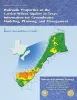
Hydraulic properties of the Carrizo-Wilcox aquifer in Texas: information for groundwater modeling, planning, and management | 2003 | Use of groundwater-flow models for prediction of future availability of water resources is standard practice. Having accurate hydraulic parameters for input into groundwater-flow models is critical to the generation of realistic local and regional water-resource management plans. |
Mace, R.E., Smyth, R.C. | Report of Investigations | Bureau of Economic Geology |
|
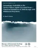
Groundwater availability in the Carrizo-Wilcox aquifer in central Texas -- numerical simulations of 2000 through 2050 withdrawal projections | 1999 | Between 1951 and 1996, groundwater pumpage from the Carrizo-Wilcox aquifer, one of Texas' major aquifer systems, increased in the area between the Colorado and Brazos Rivers from approximately 10,600 to 37,900 acre-ft/yr, primarily as a result of mining needs. |
Dutton, A.R. | Report of Investigations | Bureau of Economic Geology |
|
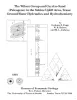
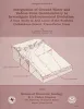
The Wilcox Group and Carrizo Sand (Paleogene) in the Sabine Uplift Area, Texas: Ground-water Hydraulics and Hydrochemistry | 1991 | Fogg, G.E., Kaiser, W.R., Ambrose, M.L., Prouty, D.A., Schultz, Susan | Geological Folios | Bureau of Economic Geology | |
|
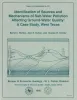
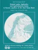
Identification of sources and mechanisms of salt-water pollution affecting ground-water quality: a case study, West Texas | 1990 | Occurrences of ground-water and soil salinization are numerous in the Concho River watershed and its confluence with the Colorado River in West Texas and in other semiarid regions of Texas and the United States. |
Richter, B.C., Dutton, A.R., Kreitler, C.W. | Report of Investigations | Bureau of Economic Geology |
|
Integration of ground-water and vadose-zone geochemistry to investigate hydrochemical evolution: a case study in arid lands of the northern Chihuahuan Desert, Trans-Pecos Texas | 1990 | The hydrochemical history of ground water in the arid southeastern Hueco Bolson and southwestern Diablo Plateau was investigated by collecting soil-moisture samples from unsaturated siliciclastic bolson-fill sediments and groundwater samples from the Diablo Plateau aquifer, the Hueco Bolson silt |
Fisher, R.S., Mullican, W.F. | Geological Circular | Bureau of Economic Geology |
|
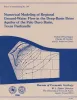
Numerical modeling of regional ground-water flow in the deep-basin brine aquifer of the Palo Duro Basin, Texas panhandle | 1986 | A conceptual hydrogeologic model of the Palo Duro Basin, Texas Panhandle, subdivides the basin into three hydrogeologic units: (1) the shallow Ogallala and Dockum aquifers (Upper aquifer), (2) the Permian evaporite aquitard (Evaporite aquitard), and (3) the deep, confined, underpressured, princip |
Wirojanagud, Prakob, Kreitler, C.W., Smith, D.A. | Report of Investigations | Bureau of Economic Geology |

|
Geology and Ground-Water Hydrology of Deep-Basin Lignite in the Wilcox Group of East Texas | 1986 | Near-surface lignite resources in Texas, or those under less than 200 feet (61 m) of cover, are ample to meet the state's demand for lignite in this century. |
Kaiser, W.R., Ambrose, M.L. | Selected Reports | Bureau of Economic Geology |
|
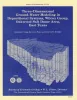
Three-dimensional ground-water modeling in depositional systems, Wilcox Group, Oakwood salt dome area, east Texas | 1983 | A three-dimensional model was constructed of ground-water flow in the Wilcox-Carrizo aquifer system near Oakwood salt dome to facilitate understanding the hydrogeology around salt domes of the Gulf interior region and ultimately to evaluate the hydrologic suitability of Oakwood Dome for storage o |
Fogg, G.E., Seni, S.J., Kreitler, C.W. | Report of Investigations | Bureau of Economic Geology |
|
Ground-water hydraulics and hydrochemical facies in Eocene aquifers of the east Texas basin | 1982 | Eocene stratigraphic units in the East Texas Basin are composed of a thick sedimentary sequence (approximately 2,000 ft [600 m]) of fresh-water aquifers and aquitards covering an area of approximately 15,000 mi2 (51,000 km2). |
Fogg, G.E., Kreitler, C.W. | Report of Investigations | Bureau of Economic Geology |
|
Faulting and Land Subsidence from Ground-Water and Hydrocarbon Production, Houston-Galveston, Texas | 1978 | Land subsidence in Harris and Galveston Counties, Texas, results from production of both ground water and hydrocarbons. |
Kreitler, C.W. | Research Note |