Publication Search

Publications tagged with San Luis Pass

Title Publication Year Abstract Author Series Publisher
Shoreline changes in the vicinity of Brazos River delta (San Luis Pass to Brown Cedar Cut) -- an analysis of historical changes of the Texas Gulf shoreline Shoreline changes in the vicinity of Brazos River delta (San Luis Pass to Brown Cedar Cut) -- an analysis of historical changes of the Texas Gulf shoreline 1975

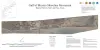
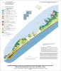
Historical monitoring in the vicinity of the Brazos River delta (San Luis Pass to Brown Cedar Cut) records the nature and magnitude of changes in position of the shoreline 'and vegetation line and provides insight into the factors affecting those changes.

Morton, R.A., Pieper, M.J. Geological Circular Bureau of Economic Geology
Geo-Environmental map of Southwest Galveston Island, San Luis Pass and Sea Isle quadrangles, Texas Gulf of Mexico Geo-Environmental map of Southwest Galveston Island, San Luis Pass and Sea Isle quadrangles, Texas Gulf of Mexico 2006 Tremblay, T.A., Gibeaut, J.C., Waldinger, R.L., White, W.A., Collins, E.W. Open-File Map Bureau of Economic Geology
Gulf of Mexico Shoreline Change, Galveston Island, Texas: San Luis Pass to Bolivar Roads 2021 Caudle, T.L., Paine, J.G., Andrews, J.R., Suarez, J.R. Posters
Gulf of Mexico Shoreline Change, Brazos River to San Luis Pass, Texas 2021 Caudle, T.L., Paine, J.G., Andrews, J.R., Suarez, J.R. Posters