New Mexico Publications
| Title | Publication Year Sort ascending | Abstract | Author | Series | Publisher | |
|---|---|---|---|---|---|---|
|
Morphometric studies of subhumid and semiarid drainage basins, Texas panhandle and northeastern New Mexico | 1987 | Data from five drainage basins in the Texas Panhandle and northeastern New Mexico characterize the recent history of regional drainage basin formation and landscape development around the margins of the Southern High Plains. |
Baumgardner, R.W., Jr., Mawhorter, J.F., Moustafa, A.R., Myers, R.M., Sandstrom, M.A. | Report of Investigations | Bureau of Economic Geology |

|
Bouguer gravity Atlas of Texas, Hobbs sheet | 1986 | This folded transparent map is at the same scale as its corresponding Geologic Atlas of Texas (GAT) sheet and can be superimposed on it to compare gravity information with surface geology. |
Keller, G.R., Aiken, C.L.V. | Bouguer Gravity Atlas of Texas | Bureau of Economic Geology |
|
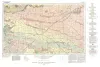
Bouguer gravity Atlas of Texas, Tucumcari sheet | 1986 | This folded transparent map is at the same scale as its corresponding Geologic Atlas of Texas (GAT) sheet and can be superimposed on it to compare gravity information with surface geology. |
Keller, G.R., Aiken, C.L.V. | Bouguer Gravity Atlas of Texas | Bureau of Economic Geology |
|
Bouguer gravity Atlas of Texas, Clovis sheet | 1985 | This folded transparent map is at the same scale as its corresponding Geologic Atlas of Texas (GAT) sheet and can be superimposed on it to compare gravity information with surface geology. |
Keller, G.R., Aiken, C.L.V. | Bouguer Gravity Atlas of Texas | Bureau of Economic Geology |
|
Late Cenozoic geomorphic evolution of the Texas panhandle and northeastern New Mexico -- case studies of structural controls on regional drainage development | 1985 | Salt dissolution has affected parts of the Upper Permian Salado, Seven Rivers, San Andres, Glorieta, and upper Clear Fork Formations beneath the Pecos River valley in eastern New Mexico and has been active beneath the Canadian River valley and the Rolling Plains of the Texas Panhandle. |
Gustavson, T.C., Finley, R.J. | Report of Investigations | Bureau of Economic Geology |
|
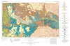
Geologic Atlas of Texas, Tucumcari sheet | 1983 | Geologic map that depicts the surface geology of Oldham County and parts of Hartley, Deaf Smith, Moore, Potter, and Randall Counties. |
Barnes, V.E., Eifler, G.K., Trauger, F.D., Spiegel, Z., Hawley, J.W., Dillon, R.L., Kottlowski, F.E., Hood, C. | Geologic Atlas of Texas | Bureau of Economic Geology |

|
Facies and stratigraphy of the San Andreas Formation, northern and northwestern shelves of the Midland basin, Texas and New Mexico | 1982 | The San Andres Formation on the Northern and Northwestern Shelves of the Midland Basin is a progradational stratigraphic unit consisting predominantly of carbonate facies. Lithofacies include dolomite, laminated anhydrite and dolomite, massive bedded anhydrite, limestone, salt, and red beds. |
Ramondetta, P.J., Guetzow, D.D., Dauzat, Rick, Merritt, R.M., Garza, John, Holman, Lee, Roques, Dominick | Report of Investigations | Bureau of Economic Geology |
|
A preliminary assessment of the geologic setting, hydrology, and geochemistry of the Hueco Tanks geothermal area, Texas and New Mexico | 1981 | The Hueco Tanks geothermal area contains five known but now inactive hot wells (50° to 71°C). The area trends north-south along the east side of Tularosa-Hueco Bolson astride the Texas-New Mexico border approximately 40 km northeast of El Paso. |
Henry, C.D., Gluck, J.K. | Geological Circular | Bureau of Economic Geology |
|
Impact of evaporite dissolution and collapse on highways and other cultural features in the Texas panhandle and eastern New Mexico | 1981 | Geological investigations in the Texas Panhandle and eastern New Mexico indicate that regional subsurface dissolution of Permian evaporites has occurred and is an ongoing process. |
Simpkins, W.W., Gustavson, T.C., Alhades, A.B., Hoadley, A.D. | Geological Circular | Bureau of Economic Geology |
|
Geologic Atlas of Texas, Clovis sheet | 1977 | Geologic map that depicts the surface geology of Parmer and Castro Counties and parts of Deaf Smith, Randall, Bailey, Lamb, and Hale Counties. |
Barnes, V.E., Eifler, G.K., Reeves, C.C., Kottlowski, F.E., Quackenbush, W.M., Grant, W.D., Hughes, C.D. | Geologic Atlas of Texas | Bureau of Economic Geology |