|
GCAGS Transactions Volume 3 (1953), Shreveport |
|
1953 |
Gulf Coast Association of Geological Societies |
|
Stratigraphy and petrology of the Tascotal Mesa quadrangle, Texas |
Erickson, R.L. |
1953 |
Report of Investigations |
|
Paleontology of the Rustler Formation, Culberson County, Texas |
Walter, J.C. |
1953 |
Report of Investigations |
|
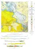
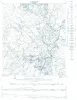
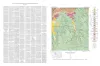
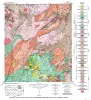
Tascotal Mesa Quadrangle, Brewster and Presidio Counties, Texas |
Erickson, R.L. |
1953 |
Miscellaneous Map |
|
Cretaceous of Llano Estacado of Texas |
Brand, J.P. |
1953 |
Report of Investigations |
|
Geology and Mineral Deposits of Pre-Cambrian Rocks of the Van Horn Area, Texas |
King, P.B., Flawn, P.T. |
1953 |
UT Publication |
|
The Geology of Henrys Chapel Quadrangle, Northeastern Cherokee County, Texas |
Stenzel, H.B. |
1953 |
UT Publication |
|
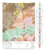
Geologic map of Chinati Peak quadrangle, Presidio County, Texas |
Rix, C.C. |
1953 |
Miscellaneous Map |
|
Recognition of Hipparions and other horses in the middle Miocene Mammalian faunas of the Texas Gulf region |
Quinn, J.H. |
1952 |
Report of Investigations |
|
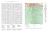
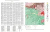
Geologic map of the Squaw Creek Quadrangle, Gillespie and Mason Counties, Texas |
Barnes, V.E. |
1952 |
Geologic Quadrangle Map |
|
GCAGS Transactions Volume 2 (1952), Corpus Christi |
|
1952 |
Gulf Coast Association of Geological Societies |
|
Geologic map of the Hilltop Quadrangle, Gillespie, Llano, and Mason Counties, Texas |
Barnes, V.E. |
1952 |
Geologic Quadrangle Map |
|
Edwards Core Study |
Feray, D.E., Jr. |
1952 |
Miscellaneous Map |
|
The Hazel copper-silver mine, Culberson County, Texas |
Flawn, P.T. |
1952 |
Report of Investigations |
|
Geologic Map of the Crabapple Creek Quadrangle Gillespie and Llano Counties, Texas |
Barnes, V.E. |
1952 |
Geologic Quadrangle Map |
|
High purity Marble Falls limestone, Burnet County, Texas |
Barnes, V.E. |
1952 |
Report of Investigations |
|
Geologic map of the Willow City quadrangle, Gillespie and Llano Counties, Texas |
Barnes, V.E. |
1952 |
Geologic Quadrangle Map |
|
Geologic Map of the Blowout Quadrangle, Blanco, Gillespie, and Llano Counties, Texas |
Barnes, V.E. |
1952 |
Geologic Quadrangle Map |
|
Geologic map of the Spring Creek Quadrangle, Gillespie County, Texas |
Barnes, V.E. |
1952 |
Geologic Quadrangle Map |
|
Geologic map of the Live Oak Creek Quadrangle, Gillespie County, Texas |
Barnes, V.E. |
1952 |
Geologic Quadrangle Map |