|
Directory Of Oil Company Name Changes |
Babcock, Paul E. |
2014 |
Houston Geological Society |
|
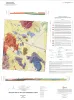
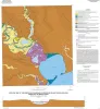
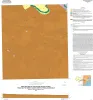
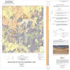
Geologic map of the Gunsight Hills South quadrangle, Texas |
Elliott, Brent A. |
2014 |
Open-File Map |
|
Sequence Stratigraphy, Depositional Systems, and Facies Complexity of the Woodbine Group in East Texas Field: Core Workshop |
Ambrose, W.A., Hentz, T.F., Loucks, R.G., Frébourg, Gregory, Potter, E.C. |
2014 |
Seminars and Workshops |
|
Sedimentary Basins: Origin, Depositional Histories, and Petroleum Systems |
|
2014 |
Gulf Coast Section SEPM |
|
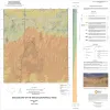
Geologic map of the Lasca quadrangle, Texas |
Elliott, Brent A. |
2014 |
Open-File Map |
|
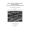
Aspects of Tertiary Sedimentary Rocks (Paleocene-Miocene), Central Texas Gulf Coast Plain, Revisited |
McBride, E.F., Woodruff, C.M., Jr., Folk, R.L., Hopkins, Janie |
2014 |
Austin Geological Society |
|
Geologic map of the Losoya quadrangle, Texas |
Elliott, Brent A. |
2014 |
Open-File Map |
|
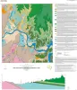
Geologic map of the Bayside quadrangle: Aransas Delta and Copano Bay Area, Texas Gulf of Mexico Coast |
Paine, J.G., Collins, E.W. |
2014 |
Open-File Map |
|
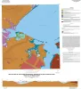
Geologic map of the Mission Bay quadrangle: Mission Delta and Copano Bay area, Texas Gulf of Mexico Coast |
Paine, J.G., Collins, E.W. |
2014 |
Open-File Map |
|
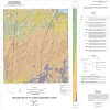
Geologic map of the Smithwick quadrangle, Texas |
Woodruff, C.M., Jr. |
2014 |
Open-File Map |
|
Annual Report of the Bureau of Economic Geology 2014 |
University of Texas at Austin, Bureau of Economic Geology |
2014 |
Annual Reports |
|
GCAGS Journal, Volume 3 (2014) |
|
2014 |
Gulf Coast Association of Geological Societies |
|
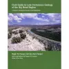
Field Guide to Late Cretaceous Geology...Big Bend |
|
2014 |
Houston Geological Society |
|
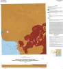
Geologic map of the Guadalupe delta, Texas Gulf of Mexico Coast: Sheet 4-Sea Drift quadrangle |
Collins, E.W., Paine, J.G. |
2013 |
Open-File Map |
|
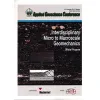
Interdisciplinary Micro to Macroscale Geomechanics |
|
2013 |
Houston Geological Society |
|
Geologic map of the Guadalupe delta, Texas Gulf of Mexico Coast: Sheet 5-Tivoli quadrangle |
Collins, E.W., Paine, J.G. |
2013 |
Open-File Map |
|
Geologic map of the Poteet quadrangle, Texas |
Elliott, Brent A. |
2013 |
Open-File Map |
|
Depositional Systems and Controls on Reservoir Quality (Determined from Core Data) in Deeply Buried Tertiary Strata in the Texas-Louisiana Gulf of Mexico |
Ambrose, W.A., Loucks, R.G., Dutton, S.P. |
2013 |
Report of Investigations |
|
Geologic map of the Thelma quadrangle, Texas |
Elliott, Brent A. |
2013 |
Open-File Map |
|
GCAGS Transactions Volume 63 (2013) New Orleans |
|
2013 |
Gulf Coast Association of Geological Societies |