|
Paleontology of the Rustler Formation, Culberson County, Texas |
Walter, J.C. |
1953 |
Report of Investigations |
|
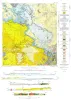
Tascotal Mesa Quadrangle, Brewster and Presidio Counties, Texas |
Erickson, R.L. |
1953 |
Miscellaneous Map |
|
Cretaceous of Llano Estacado of Texas |
Brand, J.P. |
1953 |
Report of Investigations |
|
Geology and Mineral Deposits of Pre-Cambrian Rocks of the Van Horn Area, Texas |
King, P.B., Flawn, P.T. |
1953 |
UT Publication |
|
The Geology of Henrys Chapel Quadrangle, Northeastern Cherokee County, Texas |
Stenzel, H.B. |
1953 |
UT Publication |
|
Geologic map of Chinati Peak quadrangle, Presidio County, Texas |
Rix, C.C. |
1953 |
Miscellaneous Map |
|
Geology of the Agua Fria quadrangle, Brewster County, Texas |
Moon, C.G. |
1953 |
Report of Investigations |
|
GCAGS Transactions Volume 3 (1953), Shreveport |
|
1953 |
Gulf Coast Association of Geological Societies |
|
Geologic map of the Willow City quadrangle, Gillespie and Llano Counties, Texas |
Barnes, V.E. |
1952 |
Geologic Quadrangle Map |
|
Geologic Map of the Blowout Quadrangle, Blanco, Gillespie, and Llano Counties, Texas |
Barnes, V.E. |
1952 |
Geologic Quadrangle Map |
|
Geologic map of the Spring Creek Quadrangle, Gillespie County, Texas |
Barnes, V.E. |
1952 |
Geologic Quadrangle Map |
|
Geologic map of the Live Oak Creek Quadrangle, Gillespie County, Texas |
Barnes, V.E. |
1952 |
Geologic Quadrangle Map |
|
Geologic map of the Palo Alto Creek Quadrangle, Gillespie County, Texas |
Barnes, V.E. |
1952 |
Geologic Quadrangle Map |
|
Geologic map of the Gold Quadrangle, Gillespie County, Texas |
Barnes, V.E. |
1952 |
Geologic Quadrangle Map |
|
Geologic map of the North Grape Creek Quadrangle, Blanco and Gillespie County, Texas |
Barnes, V.E. |
1952 |
Geologic Quadrangle Map |
|
Geologic map of the Morris Ranch quadrangle, Gillespie and Kerr Counties, Texas |
Barnes, V.E. |
1952 |
Geologic Quadrangle Map |
|
Geologic map of the Bear Creek quadrangle, Gillespie, Kerr, and Kendall Counties, Texas |
Barnes, V.E. |
1952 |
Geologic Quadrangle Map |
|
Geologic map of the Cain City quadrangle, Gillespie and Kendall Counties, Texas |
Barnes, V.E. |
1952 |
Geologic Quadrangle Map |
|
Correlation between surface and subsurface sections of the Ellenberger Group of Texas |
Hendricks, Leo |
1952 |
Report of Investigations |
|
Geologic map of the Stonewall quadrangle, Gillespie and Kendall Counties, Texas |
Barnes, V.E. |
1952 |
Geologic Quadrangle Map |