|
Depositional Systems and Facies Variability in the Wilcox Group in Texas: Core Workshop |
Olariu, M.I., Ambrose, W.A., Clift, S.J., Conwell, David, Li, Shunli, Olariu, Cornel, Steel, Ronald, Zeng, Hongliu, Zhang, Jinyu |
2015 |
Seminars and Workshops |
|
Austin Chalk (UK) - Stratigraphic, Geophysical, Hydrogeological and Hydrocarbon Exploration/Production Characteristics |
Lundquist, Jason, Saribudak, Mustafa, Mace, R.E., Sullivan, Charlotte, Dickerson, P.W. |
2015 |
Austin Geological Society |
|
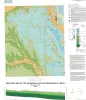
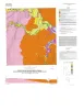
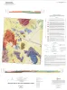
Geologic map of the Gainesville South quadrangle, Texas |
Collins, E.W. |
2015 |
Open-File Map |
|
GCAGS Transactions Volume 65 (2015) Houston |
|
2015 |
Gulf Coast Association of Geological Societies |
|
Geologic map of the Rincon Bend quadrangle, Aransas River and Copano Bay area, Texas Gulf of Mexico coast |
Paine, J.G., Collins, E.W., Costard, L. |
2015 |
Open-File Map |
|
Geologic map of the Woodsboro quadrangle: Aransas and Mission Rivers, and Copano Bay area, Texas Gulf of Mexico Coast |
Paine, J.G., Collins, E.W., Costard, L. |
2015 |
Open-File Map |
|
Highway Geology of Texas Map |
|
2015 |
AAPG |
|
Annual Report of the Bureau of Economic Geology 2015 |
University of Texas at Austin, Bureau of Economic Geology |
2015 |
Annual Reports |
|
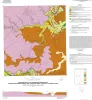
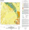
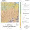
Geologic map of the Muenster West quadrangle, Texas |
Collins, E.W. |
2015 |
Open-File Map |
|
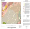
Geologic map of the Pace Bend quadrangle, Texas |
Woodruff, C.M., Jr., Collins, E.W. |
2015 |
Open-File Map |
|
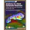
Anatomy of a Giant Carbonate Reservoir: Fullerton Clear Fork (Lower Permian) Field, Permian Basin, Texas |
Ruppel, S.C. |
2015 |
Report of Investigations |
|
GCAGS Journal, Volume 4 (2015) |
|
2015 |
Gulf Coast Association of Geological Societies |
|
Geologic map of the Silver King Canyon quadrangle, Texas |
Elliott, Brent A. |
2015 |
Open-File Map |
|
Geologic map of the Spice Rock quadrangle, Texas |
Elliott, Brent A. |
2015 |
Open-File Map |
|
Integrated Approaches of Unconventional Reservoir Assessment and Optimization, 2015 |
|
2015 |
Houston Geological Society |

|
Geomechanics in Unconventionals |
|
2015 |
Houston Geological Society |
|
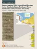
Pennsylvanian Tidal Depositional Systems in the Anadarko Basin, Northeast Texas Panhandle and Northwest Oklahoma |
Ambrose, W.A., Tussey, L.B. |
2015 |
Report of Investigations |
|
Geologic map of the Lasca quadrangle, Texas |
Elliott, Brent A. |
2014 |
Open-File Map |
|
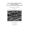
Aspects of Tertiary Sedimentary Rocks (Paleocene-Miocene), Central Texas Gulf Coast Plain, Revisited |
McBride, E.F., Woodruff, C.M., Jr., Folk, R.L., Hopkins, Janie |
2014 |
Austin Geological Society |
|
Geologic map of the Losoya quadrangle, Texas |
Elliott, Brent A. |
2014 |
Open-File Map |