|
Upper Pennsylvanian and Lower Permian Shelf, Slope, and Basin Depositional Facies of the Southern Eastern Shelf of the Midland Basin: Core Workshop |
Hentz, T.F., Ambrose, W.A., Palacios, F.C., Baumgardner, R.W., Jr. |
2017 |
Seminars and Workshops |
|
Less Frequented Springs of the Austin Area, Texas |
Cherepon, Alan J., Pope, Sylvia R., Hiers, Scott E., Berry J. L, Dickerson, P. W., Johns, D.A. |
2017 |
Austin Geological Society |
|
Canyon Dam Spillway Gorge and Natural Bridge Caverns: Geologic Excursions in the Balcones Fault Zone, Central Texas |
Woodruff, C.M., Jr., Collins, E.W., Potter, E.C., Loucks, R.G. |
2017 |
Guidebook |
|
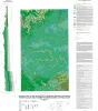
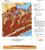
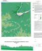
Geologic Map of the Shingle Hills-Dripping Springs-Driftwood-Rough Hollow-Henly-Hammetts Crossing Area, Central Texas |
Collins, E.W. |
2017 |
Open-File Map |
|
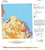
Geologic Map of the Seadrift NE Quadrangle, Texas Gulf of Mexico Coast |
Paine, J.G., Collins, E.W. |
2017 |
Open-File Map |
|
Geologic Map of the Port Lavaca East Quadrangle, Texas Gulf of Mexico Coast |
Paine, J.G., Collins, E.W. |
2017 |
Open-File Map |
|
GCAGS Transactions Volume 66 (2016) Corpus Christi |
|
2016 |
Gulf Coast Association of Geological Societies |
|
Annual Report of the Bureau of Economic Geology 2016 |
University of Texas at Austin, Bureau of Economic Geology |
2016 |
Annual Reports |

|
Texas Through Time: Lone Star Geology, Landscapes, and Resources |
Ewing, T.E., Christensen, H. |
2016 |
Udden Series |
|
GCAGS Journal, Volume 5 (2016) |
|
2016 |
Gulf Coast Association of Geological Societies |
|
Geologic map of Port O'Connor quadrangle, Texas Gulf of Mexico coast |
Paine, J.G., Collins, E.W. |
2016 |
Open-File Map |
|
Geologic map of the Saint Charles Bay quadrangle, Texas Gulf of Mexico coast |
Paine, J.G., Collins, E.W. |
2016 |
Open-File Map |
|
Integrated Approaches of Unconventional Assessment and Optimization |
|
2016 |
Houston Geological Society |
|
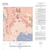
Geologic map of the Bee Cave quadrangle, Texas |
Collins, E.W. |
2016 |
Open-File Map |
|
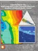
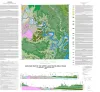
Lithofacies of the Wolfcamp and Lower Leonard Intervals, Southern Midland Basin |
Baumgardner, R.W., Jr., Hamlin, H.S., Rowe, H.D. |
2016 |
Report of Investigations |
|
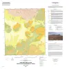
Geologic Map of the Fredonia Quadrangle, Texas |
Elliott, Brent A. |
2016 |
Open-File Map |
|
Geologic Map of the White Hills Quadrangle, Texas |
Elliott, Brent A. |
2016 |
Open-File Map |
|
Africa: What's Next? |
|
2016 |
Houston Geological Society |
|
Architectural Variability and Depositional Trends in the Wilcox Group in Texas |
Olariu, M.I., Ambrose, W.A., Clift, S.J., Clayton, Austin, Li, Shunli, Olariu, Cornel, Steel, Ronald., Zeng, Hongliu, Zhang, Jinyu |
2016 |
Seminars and Workshops |
|
Geologic map of the upper Lake Travis area, Texas |
Woodruff, C.M., Jr., Collins, E.W. |
2016 |
Miscellaneous Map |