|
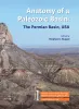
Anatomy of a Paleozoic Basin: The Permian Basin, USA (vol. 1) |
Ruppel, S.C. |
2019 |
Report of Investigations |
|
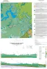
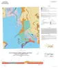
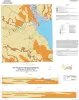
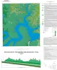
Geologic map of the lower Lake Travis and Lake Austin vicinity, Texas |
Woodruff, C.M., Jr., Collins, E.W. |
2019 |
Miscellaneous Map |
|
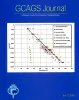
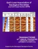
GeoGulf Transactions Volume 69 (2019) Houston |
|
2019 |
Gulf Coast Association of Geological Societies |
|
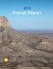
Annual Report of the Bureau of Economic Geology 2018 |
University of Texas at Austin, Bureau of Economic Geology |
2018 |
Annual Reports |
|
Geologic map of the Point Comfort quadrangle, Texas Gulf of Mexico Coast |
Paine, J.G., Collins, E.W., Costard, L. |
2018 |
Open-File Map |
|
GCAGS Journal, Volume 7 (2018) |
|
2018 |
Gulf Coast Association of Geological Societies |
|
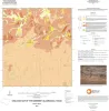
Geologic map of the Somerset quadrangle, Texas |
Elliott, Brent A. |
2018 |
Open-File Map |
|
Geologic map of Mansfield Dam, Jollyville, Austin West, and Bee Cave quadrangles, Central Texas (Lower Lake Travis and Lake Austin vicinity) |
Woodruff, C.M., Jr., Collins, E.W. |
2018 |
Open-File Map |
|
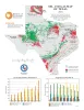
Oil and Gas Map of Texas |
Kim, E.M., Ruppel, S.C. |
2018 |
Thematic Maps |
|
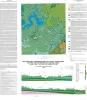
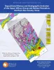
Depositional History and Stratigraphic Evolution of the Upper Wilcox Group and Reklaw Formation, Northern Bee County, Texas |
Ambrose, W.A., Zeng, Hongliu, Zhang, Jinyu, Olariu, M.I., Smith, D., Clift, S.J. |
2018 |
Report of Investigations |
|
Depositional History and Architectural Variability of the Wilcox Group in Texas: Core Workshop |
Olariu, M.I., Ambrose, W.A., Olariu, Cornel, Steel, Ronald, Zhang, Jinyu |
2018 |
Seminars and Workshops |
|
GCAGS Transactions Volume 68 (2018) Shreveport |
|
2018 |
Gulf Coast Association of Geological Societies |
|
Geologic map of the Kamey quadrangle, Texas Gulf of Mexico Coast |
Paine, J.G., Collins, E.W., Costard, L. |
2018 |
Open-File Map |
|
GCAGS Journal, Volume 6 (2017) |
|
2017 |
Gulf Coast Association of Geological Societies |
|
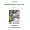
Less Frequented Springs of the Austin Area, Texas |
Cherepon, Alan J., Pope, Sylvia R., Hiers, Scott E., Berry J. L, Dickerson, P. W., Johns, D.A. |
2017 |
Austin Geological Society |
|
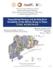
Upper Pennsylvanian and Lower Permian Shelf-to-Basin Facies Architecture and Trends, Eastern Shelf of the Southern Midland Basin, West Texas |
Hentz, T.F., Ambrose, W.A., Hamlin, H.S. |
2017 |
Report of Investigations |
|
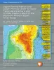
Geological CO2 Sequestration Atlas of Miocene Strata, Offshore Texas State Waters |
Treviño, R.H., Meckel, T.A. |
2017 |
Report of Investigations |
|
Geologic Map of the Mansfield Dam Quadrangle, Texas |
Woodruff, C.M., Jr. |
2017 |
Open-File Map |
|
Upper Pennsylvanian and Lower Permian Shelf, Slope, and Basin Depositional Facies of the Southern Eastern Shelf of the Midland Basin: Core Workshop |
Hentz, T.F., Ambrose, W.A., Palacios, F.C., Baumgardner, R.W., Jr. |
2017 |
Seminars and Workshops |
|
Canyon Dam Spillway Gorge and Natural Bridge Caverns: Geologic Excursions in the Balcones Fault Zone, Central Texas |
Woodruff, C.M., Jr., Collins, E.W., Potter, E.C., Loucks, R.G. |
2017 |
Guidebook |