|
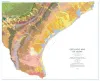
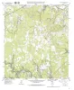
Geologic map of Texas |
University of Texas at Austin, Bureau of Economic Geology, Barnes, V.E., Hartmann, B., Scranton, D.F. |
1992 |
Thematic Maps |
|
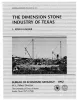
The dimension stone industry of Texas |
Garner, L.E. |
1992 |
Mineral Resource Circular |
|
Texas Portland cement industry and cement resources |
McBride, M.W., Patty, T.S., Sharpe, R.D. |
1992 |
Mineral Resource Circular |
|
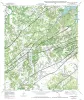
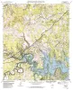
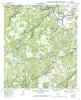
Geologic map of the Smithson Valley quadrangle, Texas |
Collins, E.W. |
1992 |
Open-File Map |
|
Geologic map of the Spring Branch Quadrangle, Texas |
Collins, E.W. |
1992 |
Open-File Map |
|
Bibliography of Gulf Coast Geology (V. 6) |
|
1992 |
Gulf Coast Association of Geological Societies |
|
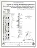
Core and Log Analyses of Depositional Systems and Reservoir Properties ... in Frio, Vicksburg, and Wilcox Sandstones |
Levey, R.A., Grigsby, J.D. |
1992 |
Geological Circular |
|
GCAGS Transactions Volume 42 (1992) Jackson |
|
1992 |
Gulf Coast Association of Geological Societies |
|
Studies on the Cave and Endogean Fauna of North America II |
|
1992 |
Texas Memorial Museum |
|
Annual Report of the Bureau of Economic Geology 1992 |
University of Texas at Austin, Bureau of Economic Geology |
1992 |
Annual Reports |
|
Surface fissures in the Hueco Bolson and adjacent basins, West Texas |
Baumgardner, R.W., Jr., Scanlon, B.R. |
1992 |
Geological Circular |
|
Geologic map of the Fischer quadrangle, Texas |
Collins, E.W. |
1992 |
Open-File Map |
|
Geologic map of the Anhalt quadrangle, Texas |
Collins, E.W. |
1992 |
Open-File Map |
|
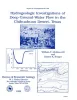
Hydrogeologic investigations of deep ground-water flow in the Chihuahuan Desert, Texas |
Mullican, W.F., Senger, R.K. |
1992 |
Report of Investigations |
|
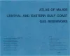
Atlas of Major Central and Eastern Gulf Coast Gas Reservoirs |
Bebout, D.G., White, W.A., Garrett, C.M., Jr., Hentz, T.F. |
1992 |
Atlases of Major Oil and Gas Reservoirs |
|
Geology of the Infiernito caldera and magmatic evolution of the Chinati Mountains, Trans-Pecos Texas |
Henry, C.D., Price, J.G., Duex, T.W., James, E.W. |
1992 |
Report of Investigations |
|
Environmental and applied tracers as indicators of liquid and vapor transport in the Chihuahuan Desert, Texas |
Scanlon, B.R. |
1992 |
Report of Investigations |
|
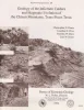
Characterization of a Karsted, High-Energy, Ramp-Margin Carbonate Reservoir: Taylor-Link West San Andres Unit, Pecos County |
Lucia, F.J., Kerans, Charles, Vander Stoep, G.W. |
1992 |
Report of Investigations |
|
The Rise and Fall of Diapirs During Thin-Skinned Extension |
Vendeville, B.C., Jackson, M.P.A. |
1992 |
Report of Investigations |
|
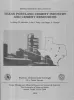
Technology Transfer Needs and Requirements for Texas Independent Oil and Gas Producers: Increasing Oil and Gas Discovery Efficiency through Advanced Technology Applications |
|
1992 |
Selected Reports |