|
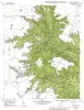
Geologic map of the Murphy School quadrangle, Texas |
Collins, E.W. |
1998 |
Open-File Map |
|
Geologic map of the Lake Theo Quadrangle, Texas |
Collins, E.W. |
1998 |
Open-File Map |
|
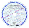
West Waha and Worsham-Bayer Fields Data Set: 3-D Seismic Data, Well Logs, and Production Records |
Major, R.P., Hardage, B.A., Lancaster, D.E., Pendleton, V.M., Remington, L.E. |
1998 |
Seminars and Workshops |
|
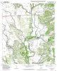
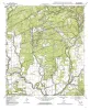
Geologic map of the Mustang Valley Quadrangle, Texas |
Collins, E.W. |
1998 |
Open-File Map |
|
Geologic map of the Fortress Cliff Quadrangle, Texas |
Raney, J.A., Collins, E.W. |
1998 |
Open-File Map |
|
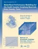
Waterflood performance modeling for the South Cowden Grayburg reservoir, Ector County, Texas |
Jennings, J.W., Jr., Lucia, F.J., Ruppel, S.C. |
1998 |
Report of Investigations |
|
Geologic map of the Quihi Quadrangle, Texas |
Collins, E.W. |
1998 |
Open-File Map |
|
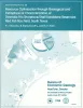
Resource optimization through geological and petrophysical characterization of downdip Frio shoreface/shelf sandstone reservoirs: Red Fish Bay field, south Texas |
Barnaby, R.J., Ramamoorthy, R., Holtz, M.H. |
1998 |
Report of Investigations |
|
Geologic map of the Rio Medina quadrangle, Texas |
Collins, E.W. |
1998 |
Open-File Map |
|
Comparison of the Recovery Behavior of Contrasting Reservoir Analogs in the Ferron Sandstone Using Outcrop Studies and Numerical Simulation |
White, C.D., Barton, M.D. |
1998 |
Report of Investigations |
|
Permeability structure of the Edwards aquifer, south Texas -- implications for aquifer management |
Hovorka, S.D., Mace, R.E., Collins, E.W. |
1998 |
Report of Investigations |
|
Bibliography of Gulf Coast Geology (V. 7) |
|
1998 |
Gulf Coast Association of Geological Societies |
|
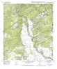
Geologic map of the Sabinal NE quadrangle, Texas |
Collins, E.W. |
1998 |
Open-File Map |
|
Architecture and Permeability Structure of a Composite Valley Fill in the Cretaceous Fall River Formation of South Dakota |
Willis, B.J. |
1998 |
Report of Investigations |
|
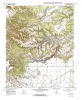
Geology of Big Bend Ranch State Park, Texas |
Henry, C.D. |
1998 |
Guidebook |
|
Geologic Controls on Reservoir Architecture and Hydrocarbon Distribution in Miocene Shoreface Fluvial and Deltaic Deposits in the Mioceno Norte Area, Lake Maracaibo, Venezuela |
Ambrose, W.A., Mendez, M., Akhter, M.S. |
1998 |
Report of Investigations |
|
3-D Seismic Stratal-Surface Concepts Applied to the Interpretation of a Fluvial Channel System... |
Hardage, B.A., Remington, R.L. |
1998 |
Geological Circular |
|
Tertiary volcanism of the Boficillos Mountains and Big Bend Ranch State Park, Texas: revised stratigraphy and 40Ar/39Ar geochronology |
Henry, C.D., Davis, L.L., Kunk, M.J., McIntosh, W.C. |
1998 |
Report of Investigations |
|
Facies and diagenesis of the Austin Chalk and controls on fracture intensity -- a case study from north-central Texas |
Hovorka, S.D. |
1998 |
Geological Circular |
|
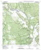
Geologic map of the Leander Quadrangle, Texas |
Collins, E.W. |
1998 |
Open-File Map |