|
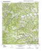
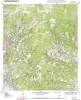
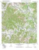
Geologic map of the Fall Creek quadrangle, Texas |
Collins, E.W. |
2004 |
Open-File Map |
|
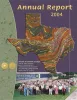
Annual Report of the Bureau of Economic Geology 2004 |
University of Texas at Austin, Bureau of Economic Geology |
2004 |
Annual Reports |
|
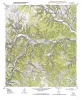
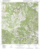
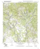
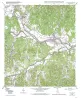
Geologic map of the Hunt quadrangle, Texas |
Collins, E.W. |
2004 |
Open-File Map |
|
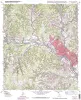
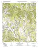
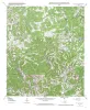
Geologic map of the Kerrville quadrangle, Texas |
Collins, E.W. |
2004 |
Open-File Map |
|
Geologic map of the Legion quadrangle, Texas |
Collins, E.W. |
2004 |
Open-File Map |
|
Geologic map of the Love Creek quadrangle, Texas |
Collins, E.W. |
2004 |
Open-File Map |
|
Geologic map of the Rock Cliff Reservoir quadrangle, Texas |
Collins, E.W. |
2004 |
Open-File Map |
|
Sandstone Architecture of...Shoreface Deltaic and Valley-fill Complexes, Macuspana Basin, Southeastern Mexico |
Ambrose, W.A., Jones, R.H., Fouad, K. |
2004 |
Report of Investigations |
|
Studies on the Cave and Endogean Fauna of North America IV |
|
2004 |
Texas Memorial Museum |
|
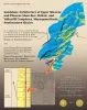
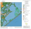
Geoenvironmental map of the Christmas Point quadrangle, Texas |
Tremblay, T.A., White, W.A., Waldinger, R.L., Collins, E.W. |
2004 |
Open-File Map |
|
Geologic map of the A Bar A quadrangle, Texas |
Collins, E.W. |
2004 |
Open-File Map |
|
Geologic map of the Bandera Pass quadrangle, Texas |
Collins, E.W. |
2004 |
Open-File Map |
|
Geologic map of the Center Point quadrangle, Texas |
Collins, E.W. |
2004 |
Open-File Map |
|
Lignite, Clay, and Water: The Wilcox Group in Central Texas |
Mace, R.E., Williams, Barry |
2004 |
Austin Geological Society |
|
Geologic map of the Echo Hill Ranch quadrangle, Texas |
Collins, E.W. |
2004 |
Open-File Map |
|
Tectonic History Southern Laurentia: A look at Mesoproterozoic, Late-Paleozoic, and Cenozoic Structures in Central Texas |
Hoh, April, Hunt, B.B. |
2004 |
Austin Geological Society |
|
GCAGS Transactions Volume 54 (2004) San Antonio |
|
2004 |
Gulf Coast Association of Geological Societies |
|
Down to Earth at Pedernales Falls State Park, Texas |
Wermund, E.G., Barnes, V.E. |
2003 |
Down To Earth |
|
Jurassic and Lower Cretaceous Stratigraphy and Tectonics of Northeast Mexico |
Humphrey, W.E., Diaz, Teodoro, Wilson, J.L., Jordan, Clif |
2003 |
Report of Investigations |
|
Salt-Related Fault Families and Fault Welds in the Northern Gulf of Mexico |
Jackson, M.P.A., Rowan, M.G. |
2003 |
Report of Investigations |