|
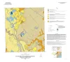
Geologic map of the Bloomington quadrangle, Texas Gulf of Mexico coast |
2020 |
|
Paine, J.G., Costard, L. |
Open-File Map |
Bureau of Economic Geology |
|
Geologic map of the Placedo quadrangle, Texas Gulf of Mexico coast |
2019 |
|
Paine, J.G., Costard, L. |
Open-File Map |
Bureau of Economic Geology |
|
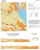
Geologic map of the Kamey quadrangle, Texas Gulf of Mexico Coast |
2018 |
|
Paine, J.G., Collins, E.W., Costard, L. |
Open-File Map |
Bureau of Economic Geology |
|
Geologic map of the Guadalupe delta, Texas Gulf of Mexico Coast: Sheet 2-Bloomington SW quadrangle |
2013 |
|
Collins, E.W., Paine, J.G. |
Open-File Map |
Bureau of Economic Geology |
|
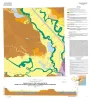
Geologic map of the Guadalupe delta, Texas Gulf of Mexico Coast: Sheet 3-Green Lake quadrangle |
2013 |
|
Paine, J.G., Collins, E.W. |
Open-File Map |
Bureau of Economic Geology |
|
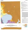
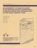
Submerged lands of Texas, Port Lavaca area: sediments, geochemistry, benthic macroinvertebrates, and associated wetlands |
1989 |
The State-owned submerged lands of Texas encompass almost 6,000 mi2 (15,540 km2). They lie below waters of the bay-estuary-lagoon system and the Gulf of Mexico and extend 10.3 mi (16.6 km) seaward from the Gulf shoreline (fig. 1). |
White, W.A., Calnan, T.R., Morton, R.A., Kimble, R.S., Littleton, T.G., McGowen, J.H., Nance, H.S. |
Submerged Lands of Texas |
Bureau of Economic Geology |
|
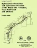
Hydrocarbon production and exploration potential of the distal Frio Formation, Texas Gulf coast and offshore |
1989 |
Along the Texas Gulf shoreline and offshore, the distal margin of the Frio Formation is a deep hydrocarbon province that is underexplored relative to the onshore Frio. |
Hamlin, H.S. |
Geological Circular |
Bureau of Economic Geology |
|
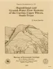
Depositional and ground-water flow systems of the Carrizo - Upper Wilcox, south Texas |
1988 |
In the Rio Grande Embayment of South Texas, the Carrizo Formation (lower Eocene) consists of two sand-rich fluvial depositional systems that grade basinward into several deltaic complexes within the upper part of the Wilcox Group. |
Hamlin, H.S. |
Report of Investigations |
Bureau of Economic Geology |
|
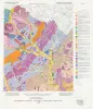
The Guadalupe - Lavaca - San Antonio - Nueces River basins regional study: Seguin West - Austin West sheets |
1985 |
|
Wermund, E.G., Gustavson, T.C., Morton, R.A., Woodruff, C.M., Jr., Macpherson, G.L., McKinney, L., Nilsson, J., Waddell, C.T. |
River Basins Regional Studies |
Bureau of Economic Geology |
|
Geochemistry of ground water in the Miocene Oakville Sandstone -- a major aquifer and uranium host of the Texas coastal plain |
1982 |
The Oakville Sandstone is a major aquifer and a major host of uranium deposits in the Texas Coastal Plain. |
Henry, C.D., Galloway, W.E., Smith, G.E., Ho, C.L., Morton, J.P., Gluck, J.K. |
Report of Investigations |
Bureau of Economic Geology |