Publications in Upton
| Title | Publication Year Sort ascending | Abstract | Author | Series | Publisher | |
|---|---|---|---|---|---|---|

|
Depositional framework of the Lower Dockum Group (Triassic), Texas panhandle | 1979 | The Upper Triassic Dockum Group of Texas and New Mexico is composed of 200 to 2,000 feet of complexly interrelated terrigenous clastic facies ranging from mudstone to conglomerate. |
McGowen, J.H., Granata, G.E., Seni, S.J. | Report of Investigations | Bureau of Economic Geology |
|
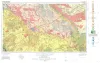
Geologic Atlas of Texas, Pecos sheet | 1976 | Geologic map that depicts the surface geology of Loving, Crane, and Ward Counties and parts of Ector, Midland, Upton, Pecos, Reeves, Crockett, and Winkler Counties, Texas. The 5-page booklet indicates geologic formations, abbreviations, and ages. |
Barnes, V.E., Eifler, G.K., Shell Oil Co., Cities Service Petroleum Co., Brown, J.B. | Geologic Atlas of Texas | Bureau of Economic Geology |

|
Geologic Atlas of Texas, San Angelo sheet | 1974 | Geologic map that depicts the surface geology of Tom Green, Irion, and Reagan Counties and parts of Midland, Glasscock, Sterling, Coke, Runnels, Concho, Menard, Schleicher, Crockett, and Upton Counties, Texas. |
Barnes, V.E., Eifler, G.K., Shell Oil Co., Southern Minerals Corp., Humble Oil and Refining Co., Cannon, Joe, Brown, W.J., Swartz, G.D. | Geologic Atlas of Texas | Bureau of Economic Geology |

|
Occurrence of Oil and Gas in West Texas | 1957 | Herald, F.A. | UT Publication | ||
|
Some uranium occurrences in West Texas | 1956 | Uranium minerals have been found at several localities in west Texas. In the King Mountain area in southwestern Upton County carnotite forms coatings along joint planes and in borings in marineCretaceous limestone. |
Eargle, D.H. | Report of Investigations | Bureau of Economic Geology |
|
Subsurface Woodford black shale, West Texas and southeast New Mexico | 1950 | The geographic distribution, lithology, thickness, and paleontology of the subsurface Woodford in the Permian basin are described and illustrated. |
Ellison Jr., S.P. | Report of Investigations | Bureau of Economic Geology |
|
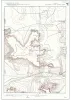
Southwest Upton County sheet, Texas | 1919 | Liddle, R.A., Prettyman, T.M., Thompson, V., Christner, D.D., Dodson, F.C., Bowman, C.E. | Miscellaneous Map | Bureau of Economic Geology |