Publications in Scurry
| Title | Publication Year Sort ascending | Abstract | Author | Series | Publisher | |
|---|---|---|---|---|---|---|
|
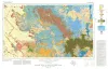
Geologic Atlas of Texas, Big Spring sheet (revised 1994) | 1974 | Geologic map that depicts the surface geology of Borden, Scurry, Fisher, Martin, Howard, Mitchell, and Nolan Counties and parts of Glasscock, Sterling, Coke, Runnels, Taylor, Jones, Dawson, Martin, Lynn, Garza, Kent, and Stonewall Counties. |
Eifler, G.K., Frye, J.C., Leonard, T.F., Barnes, V.E., Trollinger-Gusney and Assoc., Shell Oil Co., Humble Oil and Refining Co., Southern Minerals Corp. | Geologic Atlas of Texas | Bureau of Economic Geology |
|
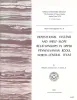
Depositional systems and shelf-slope relationships in upper Pennsylvanian rocks, north-central Texas | 1972 | The Eastern Shelf was a constructional platform developed on the margin of the sediment-starved Midland Basin during Late Pennsylvanian and Early Permian time. A mixed terrigenous-carbonate sedimentary province characterized the shelf during most of its history. |
Galloway, W.E., Brown, L.F., Jr. | Report of Investigations | Bureau of Economic Geology |
|
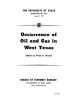
Occurrence of Oil and Gas in West Texas | 1957 | Herald, F.A. | UT Publication | ||
|
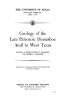
Geology of the Late Paleozoic Horseshoe Atoll in West Texas | 1956 | Myers, D.A., Stafford, P.T., Burnside, R.J. | UT Publication | ||
|
Boundary of the Pennsylvanian and Permian(?) in the subsurface Scurry reef, Scurry County, Texas | 1952 | Heck, W.A., Yenne, K.A., Henbest, L.G. | Report of Investigations | Bureau of Economic Geology |