Publications in Mills
| Title | Publication Year Sort ascending | Abstract | Author | Series | Publisher | |
|---|---|---|---|---|---|---|
|
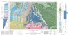
Geologic Atlas of Texas, Brownwood sheet | 1976 | Geologic map that depicts the surface geology of Mills County and parts of Runnels, Coleman, Brown, Comanche, Erath, Hamilton, Coryell, Lampasas, San Saba, McCulloch, Concho, and Menard Counties. The 21-page booklet indicates geologic formations, abbreviations, and ages. |
Kier, R.S., Harwood, P., Brown, L.F., Jr., Goodson, J.L., Barnes, V.E., Shell Oil Co., Humble Oil and Refining Co., Southern Minerals Corp. | Geologic Atlas of Texas | Bureau of Economic Geology |
|
Lower Cretaceous sands of Texas: stratigraphy and resources | 1967 | Lower Cretaceous sands have long been important aquifers in Central, North-Central, and North Texas. In recent years these sands also have been sources of high-silica industrial or specialty-purpose sand. |
Fisher, W.L., Rodda, P.U. | Report of Investigations | Bureau of Economic Geology |
|
Nomenclature revision of basal Cretaceous rocks between the Colorado and Red Rivers, Texas | 1966 | Based on need for convenient, small-scale cartographic units, the basal Cretaceous rocks in Texas from Red River to Burnet County and on the Callahan Divide are herein divided into three distinctive lithologic sequences. |
Fisher, W.L., Rodda, P.U. | Report of Investigations | Bureau of Economic Geology |
|
The Carboniferous Rocks of the Llano Region of Central Texas | 1950 | Plummer, F.B. | UT Publication | ||
|
Stratigraphic and structural studies in north central Texas | 1929 | Cheney, M.G. | UT Bulletin | ||
|
On the underground position of the Ellenburger Formation in north central Texas, with a preliminary contour map | 1918 | Sellards, E.H. | UT Bulletin | ||
|
Report on the Colorado coal field of Texas | 1917 | Drake, N.F. | UT Bulletin |