Publications in Lubbock
| Title | Publication Year Sort ascending | Abstract | Author | Series | Publisher | |
|---|---|---|---|---|---|---|
|
Sand-body geometry and depositional systems, Ogallala Formation, Texas | 1980 | The Neogene Ogallala Formation is an alluvial apron that occurs east of the Rocky Mountains from South Dakota to the Southern High Plains of Texas. The Ogallala was deposited by coalescent, low-gradient, wet alluvial fans that headed in mountains to the west. |
Seni, S.J. | Report of Investigations | Bureau of Economic Geology |
|
Regional dissolution of Permian salt in the Anadarko, Dalhart, and Palo Duro basins of the Texas panhandle | 1980 | A broad zone of salt dissolution that affects parts of the Permian Salado, Seven Rivers, San Andres, Glorieta, and upper Clear Fork Formations occurs beneath the Canadian River Valley from New Mexico eastward toward Amarillo, Texas, and southeastward parallel to the eastern Caprock Escarpment. |
Gustavson, T.C., Finley, R.J., McGillis, K.A. | Report of Investigations | Bureau of Economic Geology |
|
Geology and geohydrology of the Palo Duro Basin, Texas panhandle -- a report on the progress of nuclear waste isolation feasibility studies (1978) | 1979 | Integrated, detailed, and comprehensive study of the physical stratigraphy, tectonic history, hydrogeology, geomorphology, and resource potential of the Palo Duro and Dalhart Basins, Texas Panhandle, is part of a national evaluation of ancient salt basins as potential sites for isolation and mana |
Dutton, S.P., Finley, R.J., Galloway, W.E., Gustavson, T.C., Handford, C.R., Presley, M.W. | Geological Circular | Bureau of Economic Geology |
|
Depositional framework of the Lower Dockum Group (Triassic), Texas panhandle | 1979 | The Upper Triassic Dockum Group of Texas and New Mexico is composed of 200 to 2,000 feet of complexly interrelated terrigenous clastic facies ranging from mudstone to conglomerate. |
McGowen, J.H., Granata, G.E., Seni, S.J. | Report of Investigations | Bureau of Economic Geology |
|
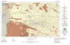
Geologic Atlas of Texas, Brownfield sheet | 1974 | Geologic map that depicts the surface geology of Cochran and Hockley Counties and parts of Bailey, Lamb, Yoakum, Terry, Hale, Lubbock, and Lynn Counties. |
Barnes, V.E., Eifler, G.K., Reeves, C.C., Kottlowski, F.E., Brown, J.B., Briscoe, J.A., DesCamps, J.R., Cities Service Petroleum Co. | Geologic Atlas of Texas | Bureau of Economic Geology |
|
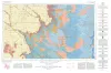
Geologic Atlas of Texas, Lubbock sheet (revised 1993) | 1967 | Geologic map that depicts surface geology of Crosby, Dickens, and King Counties and parts of Hale, Floyd, Motley, Cottle, King, Lubbock, Lynn, Garza, Kent, and Stonewall Counties. The Lubbock Sheet honors the late Dr. |
Eifler, G.K., Frye, J.C., Leonard, A.B., Hentz, T.F., Barnes, V.E. | Geologic Atlas of Texas | Bureau of Economic Geology |
|
Occurrence of Oil and Gas in West Texas | 1957 | Herald, F.A. | UT Publication | ||
|
Subsurface Woodford black shale, West Texas and southeast New Mexico | 1950 | The geographic distribution, lithology, thickness, and paleontology of the subsurface Woodford in the Permian basin are described and illustrated. |
Ellison Jr., S.P. | Report of Investigations | Bureau of Economic Geology |